IMAGES TAKEN NEAR TO
CHULMLEIGH, EX18 7AE
Introduction
This page details the photographs taken nearby to EX18 7AE by members of the Geograph project.
The Geograph project started in 2005 with the aim of publishing, organising and preserving representative images for every square kilometre of Great Britain, Ireland and the Isle of Man.

There are currently over 7.5m images from over14,400 individuals and you can help contribute to the project by visiting https://www.geograph.org.uk
Image Map (Loading...)


Getting Data...Please wait
Leaflet Map data © OpenStreetMap
Images are licensed for reuse under creativecommons.org/licenses/by-sa/2.0
Notes
- Clicking on the map will re-center to the selected point.
- The higher the marker number, the further away the image location is from the centre of the postcode.
Image Listing (10 Images Found)
Images are licensed for reuse under creativecommons.org/licenses/by-sa/2.0
Image
Details
Distance
1
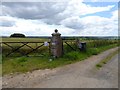
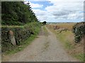
Access road to Thurle
Very solid gatepost for the farm track; at the gate one could buy either hen's eggs or duck's eggs
Image: © David Smith
Taken: 7 Aug 2015
0.13 miles
2
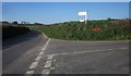
Parsonage Cross
Placing Image in more context, with the lane to Chulmleigh Beacon on the left. I wonder what the red arrow is about?
Image: © Derek Harper
Taken: 21 Apr 2015
0.17 miles
4
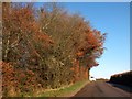
Bank as a field boundary at Parsonage Cross
The field is one of several which are bounded by earth banks beside the minor road from Chulmleigh to South Molton
Image: © David Smith
Taken: 9 Dec 2013
0.17 miles
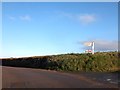
5
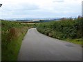
Landscape south of Chulmleigh Beacon
From the slope below the beacon (210 metres above sea level) the road drops gradually, giving a view south towards Dartmoor on the horizon
Image: © David Smith
Taken: 7 Aug 2015
0.18 miles
6
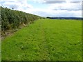
Track beside the woodland south of Chulmleigh Beacon
Image: © David Smith
Taken: 7 Aug 2015
0.19 miles
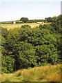
7
Woodland south of Chulmleigh Beacon
A patch of managed evergreen woods
Image: © David Smith
Taken: 7 Aug 2015
0.19 miles
8
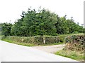
Woodland near Parsonage Cross
A small patch of woodland on the side of the minor road from Chulmleigh to South Molton
Image: © David Smith
Taken: 9 Dec 2013
0.22 miles
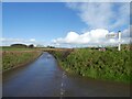
9
Footpath south of Parsonage Cross
The well-used footpath crosses several fields between Parsonage Cross and Chulmleigh recreation ground, and avoids the narrow country road. On a clear day, one can see Dartmoor on the horizon
Image: © David Smith
Taken: 7 Aug 2015
0.22 miles
10
Farm buildings near Thurle
A detail of the scene in Image], looking across the Ford Brook valley. The wide structure to the right of the barn is a circular tank.
Image: © Derek Harper
Taken: 22 Aug 2013
0.23 miles