IMAGES TAKEN NEAR TO
Lapford, CREDITON, EX17 6QX
Introduction
This page details the photographs taken nearby to EX17 6QX by members of the Geograph project.
The Geograph project started in 2005 with the aim of publishing, organising and preserving representative images for every square kilometre of Great Britain, Ireland and the Isle of Man.

There are currently over 7.5m images from over14,400 individuals and you can help contribute to the project by visiting https://www.geograph.org.uk
Image Map
Images are licensed for reuse under creativecommons.org/licenses/by-sa/2.0
Notes
- Clicking on the map will re-center to the selected point.
- The higher the marker number, the further away the image location is from the centre of the postcode.
Image Listing (20 Images Found)
Images are licensed for reuse under creativecommons.org/licenses/by-sa/2.0
Image
Details
Distance
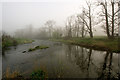
2
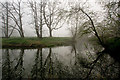
Looking up the River Yeo from the River Taw
Image: © Roger A Smith
Taken: 8 Apr 2017
0.11 miles
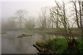
3

The River Yeo joining the River Taw near Chenson
Image: © Roger A Smith
Taken: 8 Apr 2017
0.13 miles
4
The River Taw where it is joined by the River Yeo near Chenson
Image: © Roger A Smith
Taken: 8 Apr 2017
0.14 miles
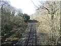
5
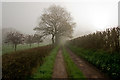
Lane to Nymet Bridge
The lane is following the west side of a ridge between the valleys of the Taw (left) and the Yeo, and is about to drop to cross the latter.
Image: © Derek Harper
Taken: 23 Mar 2011
0.14 miles
6
Looking down the River Taw where it is joined by the River Yeo
Image: © Roger A Smith
Taken: 8 Apr 2017
0.15 miles
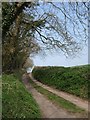
7
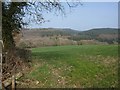
Yeo valley
The well-wooded valley seen across a field from the lane between Nymet Rowland and Nymet Bridge.
Image: © Derek Harper
Taken: 23 Mar 2011
0.17 miles
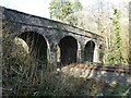
10
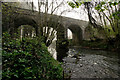
The downstream side of Nymet Bridge on the River Yeo
Image: © Roger A Smith
Taken: 8 Apr 2017
0.20 miles