IMAGES TAKEN NEAR TO
Lapford, CREDITON, EX17 6QN
Introduction
This page details the photographs taken nearby to EX17 6QN by members of the Geograph project.
The Geograph project started in 2005 with the aim of publishing, organising and preserving representative images for every square kilometre of Great Britain, Ireland and the Isle of Man.

There are currently over 7.5m images from over14,400 individuals and you can help contribute to the project by visiting https://www.geograph.org.uk
Image Map
Images are licensed for reuse under creativecommons.org/licenses/by-sa/2.0
Notes
- Clicking on the map will re-center to the selected point.
- The higher the marker number, the further away the image location is from the centre of the postcode.
Image Listing (75 Images Found)
Images are licensed for reuse under creativecommons.org/licenses/by-sa/2.0
Image
Details
Distance


5

Lapford : Eastington Lane
A small lane heading off to the right.
Image: © Lewis Clarke
Taken: 11 Jun 2017
0.11 miles
6

Lapford : Eastington Lane
Looking along the road.
Image: © Lewis Clarke
Taken: 11 Jun 2017
0.12 miles
7
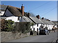
Terrace of cottages, main street, Lapford
Image: © Roger Cornfoot
Taken: 8 Mar 2010
0.12 miles
8

West Lane leading to West Farm, Lapford
Image: © David Smith
Taken: 18 Nov 2011
0.13 miles
9
Lapford : Moorland View
The rear of homes on Moorland View.
Image: © Lewis Clarke
Taken: 11 Jun 2017
0.14 miles