IMAGES TAKEN NEAR TO
Lapford, CREDITON, EX17 6NG
Introduction
This page details the photographs taken nearby to EX17 6NG by members of the Geograph project.
The Geograph project started in 2005 with the aim of publishing, organising and preserving representative images for every square kilometre of Great Britain, Ireland and the Isle of Man.

There are currently over 7.5m images from over14,400 individuals and you can help contribute to the project by visiting https://www.geograph.org.uk
Image Map
Images are licensed for reuse under creativecommons.org/licenses/by-sa/2.0
Notes
- Clicking on the map will re-center to the selected point.
- The higher the marker number, the further away the image location is from the centre of the postcode.
Image Listing (15 Images Found)
Images are licensed for reuse under creativecommons.org/licenses/by-sa/2.0
Image
Details
Distance
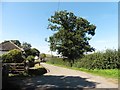
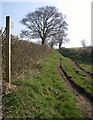
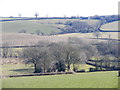
4
Morchard Bishop: Back Lane
A bridleway which will probably be re-designated a restricted byway. Looking east-north-east
Image: © Martin Bodman
Taken: 3 Aug 2006
0.04 miles
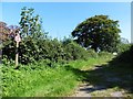
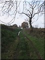
5
Back Lane
From its junction with the lane east of Rudge Rew, and also shown in Image and Image The green lane is now followed by Morchard Bishop Restricted Byway 52, but the current OS 1:25000 and 1:50000 maps don't show it as a right of way at all.
Image: © Derek Harper
Taken: 23 Mar 2011
0.04 miles
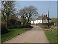
6
Back Lane (restricted byway) with Rudge Rew in the distance
Image: © David Smith
Taken: 15 Nov 2011
0.05 miles
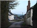
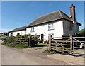
7
Rudge Rew
Farm cottages on the lane opposite the farm at Rudge Rew.
Image: © Derek Harper
Taken: 23 Mar 2011
0.06 miles
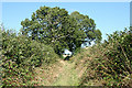
10

Restricted bridleway near Morchard Bishop
Image: © Sarah Charlesworth
Taken: 9 Sep 2009
0.07 miles