IMAGES TAKEN NEAR TO
Lapford, CREDITON, EX17 6LX
Introduction
This page details the photographs taken nearby to EX17 6LX by members of the Geograph project.
The Geograph project started in 2005 with the aim of publishing, organising and preserving representative images for every square kilometre of Great Britain, Ireland and the Isle of Man.

There are currently over 7.5m images from over14,400 individuals and you can help contribute to the project by visiting https://www.geograph.org.uk
Image Map
Images are licensed for reuse under creativecommons.org/licenses/by-sa/2.0
Notes
- Clicking on the map will re-center to the selected point.
- The higher the marker number, the further away the image location is from the centre of the postcode.
Image Listing (8 Images Found)
Images are licensed for reuse under creativecommons.org/licenses/by-sa/2.0
Image
Details
Distance

2
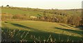
Parsonage Farm
Set in a valley just northeast of Lapford, and seen here from a lay-by on the road to Blackberry Gate.
Image: © Derek Harper
Taken: 19 Jan 2011
0.05 miles
5

Gate on footpath near Lapford
Footpath from Parsonage Farm to Great Hole Farm.
Image: © Philip Halling
Taken: 1 Apr 2006
0.18 miles
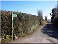
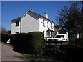
6
Public footpath and track to Parsonage Farm
The white house is Blackberry Gate
Image: © David Smith
Taken: 18 Nov 2011
0.18 miles
7
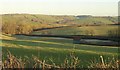
Countryside north of Lapford
From the same spot as Image looking to the right. Behind the barns runs the farm lane to Parsonage Farm, and from the farm and the trees on the left, a valley runs away to meet the River Dalch in the middle distance.
Image: © Derek Harper
Taken: 19 Jan 2011
0.19 miles
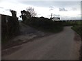
8
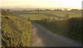
Road near Blackberry Gate
Looking in other direction from the same spot as Image, towards Lapford, in late afternoon winter sunshine. The white car is on the same road after it has swung right and left. Very faint in the hazy distance is Dartmoor.
Image: © Derek Harper
Taken: 19 Jan 2011
0.23 miles