IMAGES TAKEN NEAR TO
Zeal Monachorum, CREDITON, EX17 6LD
Introduction
This page details the photographs taken nearby to EX17 6LD by members of the Geograph project.
The Geograph project started in 2005 with the aim of publishing, organising and preserving representative images for every square kilometre of Great Britain, Ireland and the Isle of Man.

There are currently over 7.5m images from over14,400 individuals and you can help contribute to the project by visiting https://www.geograph.org.uk
Image Map
Images are licensed for reuse under creativecommons.org/licenses/by-sa/2.0
Notes
- Clicking on the map will re-center to the selected point.
- The higher the marker number, the further away the image location is from the centre of the postcode.
Image Listing (8 Images Found)
Images are licensed for reuse under creativecommons.org/licenses/by-sa/2.0
Image
Details
Distance
1
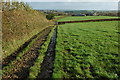
Bridleway to Wootton Top
Bridleway and track along side the hedgerow to Wootton Top Farm which can be seen in the middle distance.
Image: © Philip Halling
Taken: 15 Nov 2009
0.09 miles
2
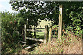
Zeal Monachorum: footpath to Gillhouse
Looking north-north-west by a stile. The signpost points to the path’s south-westerly continuation across a lane to Wootton Top
Image: © Martin Bodman
Taken: 8 Aug 2006
0.14 miles
3
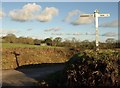
Three Crossways
A lane junction north of Wootton Top. In the background is the farm at Gillhouse.
Image: © Derek Harper
Taken: 18 Jan 2011
0.16 miles
4
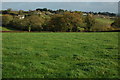
Approaching Zeal Monachorum
Approaching Zeal Monachorum on a footpath across farmland from Wootton Top.
Image: © Philip Halling
Taken: 15 Nov 2009
0.18 miles
5

Farmland west of Zeal Monachorum
View across Farmland west of Zeal Monachorum towards Wootton Top which can be seen in the middle distance to the left of centre.
Image: © Philip Halling
Taken: 15 Nov 2009
0.19 miles
6
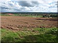
Ploughed field next to entrance to Reeve Castle
Looking towards Burston Farm
Image: © David Gearing
Taken: 27 Apr 2015
0.20 miles
7
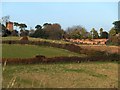
Water Tower and walled garden at Reeve Castle
The water tower is just in Image The folly (Reeve Castle) is described in Image The water tower is part of the garden features, used to supply the water features in the elaborate gardens. An aerial view of the walled garden shows that it is half an octagon
Image: © David Smith
Taken: 14 Nov 2012
0.21 miles
8
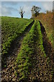
Bridleway above Wootton Top
Bridleway between Wootton Top and Burrow to the south-west of Zeal Monachorum.
Image: © Philip Halling
Taken: 15 Nov 2009
0.21 miles