IMAGES TAKEN NEAR TO
East Leigh, CREDITON, EX17 6FN
Introduction
This page details the photographs taken nearby to EX17 6FN by members of the Geograph project.
The Geograph project started in 2005 with the aim of publishing, organising and preserving representative images for every square kilometre of Great Britain, Ireland and the Isle of Man.

There are currently over 7.5m images from over14,400 individuals and you can help contribute to the project by visiting https://www.geograph.org.uk
Image Map
Images are licensed for reuse under creativecommons.org/licenses/by-sa/2.0
Notes
- Clicking on the map will re-center to the selected point.
- The higher the marker number, the further away the image location is from the centre of the postcode.
Image Listing (16 Images Found)
Images are licensed for reuse under creativecommons.org/licenses/by-sa/2.0
Image
Details
Distance
1
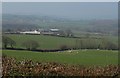
Towards East Leigh
From the point where Zeal Monachorum Footpath 7 meets the ridge lane near Southdown, looking across sheep-grazed fields. All but the nearest farm buildings at Trinity Leigh are in Image
Image: © Derek Harper
Taken: 23 Mar 2011
0.05 miles
2
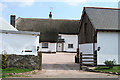
Coldridge: Trinity Leigh
Looking south on the lane between Gilscott Cross and East Leigh; near the latter. A farmhouse with a courtyard enclosed with barns.
Image: © Martin Bodman
Taken: 8 Aug 2006
0.05 miles
3
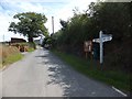
East Leigh Cross
The name on the signpost does not follow the standard layout of signposts in the county; normally the letters are vertical and read down the post
Image: © David Smith
Taken: 16 Aug 2013
0.12 miles

5
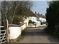
East Leigh
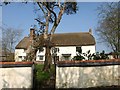
On the left is the cob wall surrounding East Leigh House http://www.britishlistedbuildings.co.uk/en-95588-east-leigh-house-incuding-cob-and-stone-g . Beyond the junction with Chilverton Cross (left) are a pair of C17 cottages listed together http://www.britishlistedbuildings.co.uk/en-95589-the-old-smithy-coldridge .
Image: © Derek Harper
Taken: 23 Mar 2011
0.14 miles
6

Thatched cottages at East Leigh
Leaning against the wall is a stone roller, now used to protect the cob wall from damage by traffic
Image: © David Smith
Taken: 16 Aug 2013
0.16 miles
7
East Leigh House
The listed former farmhouse http://www.britishlistedbuildings.co.uk/en-95588-east-leigh-house-incuding-cob-and-stone-g has C16 origins. The wall in the foreground is specifically included in the listing.
Image: © Derek Harper
Taken: 23 Mar 2011
0.17 miles
8
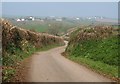
Chilverton Cross
The lane drops away from East Leigh, crossing a dip before the Coldridge Brook valley. The farm on the left is Higher Chilverton, in Image
Image: © Derek Harper
Taken: 23 Mar 2011
0.18 miles
9

Farm buildings at East Leigh
This building appears to have been a horse gin, attached to the barn beyond
Image: © David Smith
Taken: 16 Aug 2013
0.20 miles
