IMAGES TAKEN NEAR TO
Down St. Mary, CREDITON, EX17 6DT
Introduction
This page details the photographs taken nearby to EX17 6DT by members of the Geograph project.
The Geograph project started in 2005 with the aim of publishing, organising and preserving representative images for every square kilometre of Great Britain, Ireland and the Isle of Man.

There are currently over 7.5m images from over14,400 individuals and you can help contribute to the project by visiting https://www.geograph.org.uk
Image Map
Images are licensed for reuse under creativecommons.org/licenses/by-sa/2.0
Notes
- Clicking on the map will re-center to the selected point.
- The higher the marker number, the further away the image location is from the centre of the postcode.
Image Listing (62 Images Found)
Images are licensed for reuse under creativecommons.org/licenses/by-sa/2.0
Image
Details
Distance
1

Mid Devon : Nymphayes Farm
Cattle grazing in a barn at Nymphayes Farm.
Image: © Lewis Clarke
Taken: 11 Jun 2017
0.02 miles
2

Mid Devon : Nymphayes Farm
Cattle in the barn.
Image: © Lewis Clarke
Taken: 11 Jun 2017
0.04 miles
3

Mid Devon : Nymphayes Farm
Looking towards cows in a cattle shed at Nymphayes Farm.
Image: © Lewis Clarke
Taken: 11 Jun 2017
0.05 miles
4

Mid Devon : Nymphayes Farm
A tractor and some cattle in the barn.
Image: © Lewis Clarke
Taken: 11 Jun 2017
0.05 miles
5

Mid Devon : Nymphayes Farm
Looking along a track through Nymphayes Farm.
Image: © Lewis Clarke
Taken: 11 Jun 2017
0.05 miles
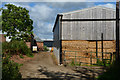
6
Mid Devon : Nymphayes Farm
A farm with a right of way passing through.
Image: © Lewis Clarke
Taken: 11 Jun 2017
0.06 miles
7

Farm driveway to Nymphayes
The farm at the end of the drive is located in the next grid square.
Image: © Philip Halling
Taken: 18 May 2008
0.10 miles

9

Mid Devon : The B3220
Looking along the B3220 from the junction with Nymphayes Lane.
Image: © Lewis Clarke
Taken: 11 Jun 2017
0.12 miles
10

Old Milestone by the B3220, Yeo Bridge
Carved stone post by the B3220, in parish of Zeal Monachorum (Mid Devon District), West of, and opposite junction with Nymphayes Lane and Yeo Bridge, in stone hedge bank, just West of new fence, on North side of road. Torrington wedge, erected by the Great Torrington turnpike trust in the 19th century.
Inscription reads:-
: 15 / Miles / EXON : : 19 / Miles / Torrington :
Grade II listed.
List Entry Number: 1106575 https://historicengland.org.uk/listing/the-list/list-entry/1106575
Milestone Society National ID: DV_GTEX19
Image: © A Rosevear
Taken: 28 Jan 2012
0.13 miles