IMAGES TAKEN NEAR TO
Coldridge, CREDITON, EX17 6BR
Introduction
This page details the photographs taken nearby to EX17 6BR by members of the Geograph project.
The Geograph project started in 2005 with the aim of publishing, organising and preserving representative images for every square kilometre of Great Britain, Ireland and the Isle of Man.

There are currently over 7.5m images from over14,400 individuals and you can help contribute to the project by visiting https://www.geograph.org.uk
Image Map
Images are licensed for reuse under creativecommons.org/licenses/by-sa/2.0
Notes
- Clicking on the map will re-center to the selected point.
- The higher the marker number, the further away the image location is from the centre of the postcode.
Image Listing (16 Images Found)
Images are licensed for reuse under creativecommons.org/licenses/by-sa/2.0
Image
Details
Distance
1
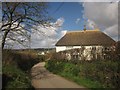
Thatched house, Holm
The C16-C17 thatched farmhouse is described at http://list.english-heritage.org.uk/resultsingle.aspx?uid=1325841&searchtype=mapsearch . The lane leads from Holm Cross to Coldridge Bridge.
Image: © Derek Harper
Taken: 19 Apr 2013
0.02 miles
2

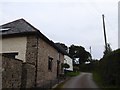
Lane past Holm
A little further down the lane shown in Image], with a pair of cottages at Holm Farm.
Image: © Derek Harper
Taken: 19 Apr 2013
0.02 miles
3
Holm on Holm Hill
A farm and barn conversion by the minor road from Coldridge Bridge
Image: © David Smith
Taken: 15 Sep 2016
0.02 miles
4
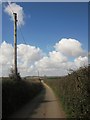
Westacott Lane
A no through road that leads only to the farm at Westacott, on the slopes of the Taw valley.
Image: © Derek Harper
Taken: 19 Apr 2013
0.06 miles

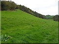
6
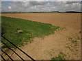
Field near Coldridge
Looking to the left across the field shown in Image The distant landscape is across the Taw valley.
Image: © Derek Harper
Taken: 19 Apr 2013
0.09 miles
7

View from Holm Wood to Taw valley
A gateway for the bridleway into the valley from Holm Hill and Holm Wood
Image: © David Smith
Taken: 15 Sep 2016
0.16 miles
8
Bridleway to Holm
The bridleway follows the lane at the edge of the wood on the left. Below, the grass slopes to the floodplain of the River Taw
Image: © David Smith
Taken: 27 Oct 2014
0.17 miles
9
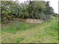
Site of a small quarry near Holm
A bridleway and lane from Coldridge to the west. At the edge of the floodplain of the River Taw, this area has been excavated as some kind of quarry. Formerly the track led to a well and building close to the photographer
Image: © David Smith
Taken: 27 Oct 2014
0.17 miles
10
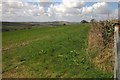
Farmland near Coldridge
Part of a large triangular field between lanes north of Burrowpit Cross.
Image: © Derek Harper
Taken: 19 Apr 2013
0.17 miles