IMAGES TAKEN NEAR TO
Yeoford, CREDITON, EX17 5HD
Introduction
This page details the photographs taken nearby to EX17 5HD by members of the Geograph project.
The Geograph project started in 2005 with the aim of publishing, organising and preserving representative images for every square kilometre of Great Britain, Ireland and the Isle of Man.

There are currently over 7.5m images from over14,400 individuals and you can help contribute to the project by visiting https://www.geograph.org.uk
Image Map
Images are licensed for reuse under creativecommons.org/licenses/by-sa/2.0
Notes
- Clicking on the map will re-center to the selected point.
- The higher the marker number, the further away the image location is from the centre of the postcode.
Image Listing (6 Images Found)
Images are licensed for reuse under creativecommons.org/licenses/by-sa/2.0
Image
Details
Distance
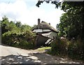
2
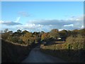
Enterlake Farm
The farm buildings are on the right after the dip in the road
Image: © David Smith
Taken: 11 Nov 2012
0.16 miles
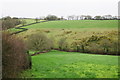
3
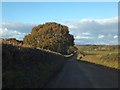
Minor road north of Enterlake Farm
The minor road climbs to a spot height of 145m, and this is the view of the slope to the north and the valley beyond shortly after that highest point
Image: © David Smith
Taken: 11 Nov 2012
0.16 miles