IMAGES TAKEN NEAR TO
Yeoford, CREDITON, EX17 5ET
Introduction
This page details the photographs taken nearby to EX17 5ET by members of the Geograph project.
The Geograph project started in 2005 with the aim of publishing, organising and preserving representative images for every square kilometre of Great Britain, Ireland and the Isle of Man.

There are currently over 7.5m images from over14,400 individuals and you can help contribute to the project by visiting https://www.geograph.org.uk
Image Map
Images are licensed for reuse under creativecommons.org/licenses/by-sa/2.0
Notes
- Clicking on the map will re-center to the selected point.
- The higher the marker number, the further away the image location is from the centre of the postcode.
Image Listing (32 Images Found)
Images are licensed for reuse under creativecommons.org/licenses/by-sa/2.0
Image
Details
Distance
1
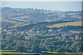
Mid Devon : Countryside Scenery
Looking across the countryside towards Yeoford.
Image: © Lewis Clarke
Taken: 2 Sep 2018
0.07 miles
2
Mid Devon : Countryside Scenery
Looking out across the countryside near Yeoford.
Image: © Lewis Clarke
Taken: 2 Sep 2018
0.08 miles
3
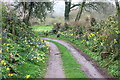
Daffodils by the Track
Daffodils brighten up this track on a damp Spring day. The track is also a public footpath and part of the Devonshire Heartland Way.
Image: © Tony Atkin
Taken: 18 Mar 2017
0.19 miles
4
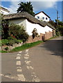
Thatched roof near Yeoford
Alongside the road to Neopardy, beyond this http://www.geograph.org.uk/photo/4699540 Yeoford northern boundary sign.
Image: © Jaggery
Taken: 13 Oct 2015
0.19 miles
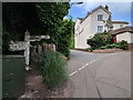
5
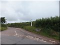
Junction at the northern edge of Yeoford
Left for Keymelford, right for Neopardy in rural Devon.
Image: © Jaggery
Taken: 13 Oct 2015
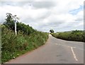
0.21 miles
7
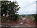
Brandise Cross (or Corner)
The sign reads "Brandise Corner" but the name is different on the OS map. This view looking south shows a modern farm track which appears to form the fourth arm of the cross or corner. However, Victorian OS maps do not show this track; instead, they show another farm track to the east which no longer exists, so this junction had three arms in the past. The word "brandise" referred to a domestic trivet, suggesting that this name might refer to a three way junction
Image: © David Smith
Taken: 17 Jul 2011
0.21 miles
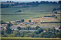
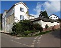
8
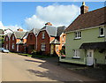
Yeoford houses
Houses in the north of the village in the Mid Devon district of Devon. The four semi-detached brick cottages are examples of farmworkers' dwellings built for the Shelley estate in early 20th century.
Image: © Jaggery
Taken: 13 Oct 2015
0.21 miles
9
Keymelford Cross (minor road junction)
The stone structure on the right appears to be a stand for milk-churns
Image: © David Smith
Taken: 17 Jul 2011
0.22 miles