IMAGES TAKEN NEAR TO
Spreyton, CREDITON, EX17 5AA
Introduction
This page details the photographs taken nearby to EX17 5AA by members of the Geograph project.
The Geograph project started in 2005 with the aim of publishing, organising and preserving representative images for every square kilometre of Great Britain, Ireland and the Isle of Man.

There are currently over 7.5m images from over14,400 individuals and you can help contribute to the project by visiting https://www.geograph.org.uk
Image Map
Images are licensed for reuse under creativecommons.org/licenses/by-sa/2.0
Notes
- Clicking on the map will re-center to the selected point.
- The higher the marker number, the further away the image location is from the centre of the postcode.
Image Listing (5 Images Found)
Images are licensed for reuse under creativecommons.org/licenses/by-sa/2.0
Image
Details
Distance
1
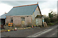
Former Coombe Head Chapel
The redundant chapel is undergoing conversion to a dwelling. The gravestones will be kept in position.
Image: © Derek Harper
Taken: 6 Mar 2018
0.07 miles
2
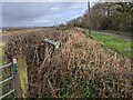
Public Footpath sign knocked over in the hedge
Image: © Rob Purvis
Taken: 13 Mar 2020
0.13 miles
3
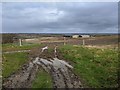
Footpath heading into a muddy field near Blue Violet
Image: © Rob Purvis
Taken: 13 Mar 2020
0.14 miles
4
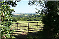
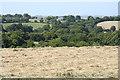
Bow: towards Nymetwood
Looking south-south-east. ‘Nymet’ has celtic origins: ‘Nemed’ is old Irish for ‘Sacred grove’. Nymet and its derivatives occur over an area of mid Devon: King’s Nympton is further north
Image: © Martin Bodman
Taken: 14 Jul 2006
0.22 miles
5
Bow: towards Little Hilldown
Overlooking Northernwood Brake, looking north-north-west
Image: © Martin Bodman
Taken: 14 Jul 2006
0.23 miles