IMAGES TAKEN NEAR TO
Black Dog, CREDITON, EX17 4RJ
Introduction
This page details the photographs taken nearby to EX17 4RJ by members of the Geograph project.
The Geograph project started in 2005 with the aim of publishing, organising and preserving representative images for every square kilometre of Great Britain, Ireland and the Isle of Man.

There are currently over 7.5m images from over14,400 individuals and you can help contribute to the project by visiting https://www.geograph.org.uk
Image Map
Images are licensed for reuse under creativecommons.org/licenses/by-sa/2.0
Notes
- Clicking on the map will re-center to the selected point.
- The higher the marker number, the further away the image location is from the centre of the postcode.
Image Listing (40 Images Found)
Images are licensed for reuse under creativecommons.org/licenses/by-sa/2.0
Image
Details
Distance
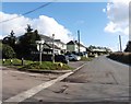
1

Black Dog : Road
A road through the village of Black Dog.
Image: © Lewis Clarke
Taken: 30 May 2019
0.03 miles
2

Black Dog : Houses
Houses along the road at Black Dog.
Image: © Lewis Clarke
Taken: 30 May 2019
0.04 miles
3
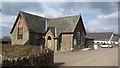
Hele Lane Methodist Church
Chapel at Black Dog, the building looks like an 1870s school.
Image: © Richard Webb
Taken: 2 Apr 2012
0.05 miles

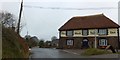
7

Crossroads, Black Dog
The pub is on the right.
Image: © Richard Webb
Taken: 2 Apr 2012
0.06 miles
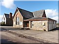
9

Washford Pyne: Hele Lane Methodist Church
At Black Dog. Looking north-north-east
Image: © Martin Bodman
Taken: 3 Oct 2006
0.06 miles
