IMAGES TAKEN NEAR TO
Black Dog, CREDITON, EX17 4QR
Introduction
This page details the photographs taken nearby to EX17 4QR by members of the Geograph project.
The Geograph project started in 2005 with the aim of publishing, organising and preserving representative images for every square kilometre of Great Britain, Ireland and the Isle of Man.

There are currently over 7.5m images from over14,400 individuals and you can help contribute to the project by visiting https://www.geograph.org.uk
Image Map
Images are licensed for reuse under creativecommons.org/licenses/by-sa/2.0
Notes
- Clicking on the map will re-center to the selected point.
- The higher the marker number, the further away the image location is from the centre of the postcode.
Image Listing (5 Images Found)
Images are licensed for reuse under creativecommons.org/licenses/by-sa/2.0
Image
Details
Distance
1
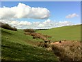
Footpath from Wonham to Lower Black Dog
The footpath from Wonham to Lower Black Dog crosses this small stream draining Washford Moor by a footbridge.
Image: © Hugh Craddock
Taken: 19 Mar 2012
0.18 miles
2
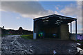
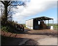
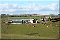
Mid Devon : Barn
A barn off of Peter's Well Hill.
Image: © Lewis Clarke
Taken: 28 Nov 2017
0.21 miles
4
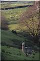
Mid Devon : Grassy Field & Alpaca
An alpaca on the hillside surrounded by countryside.
Image: © Lewis Clarke
Taken: 28 Nov 2017
0.24 miles
5
Washford Pyne: towards Sentrys
Looking north from a bridleway which runs west to Hele Lane
Image: © Martin Bodman
Taken: 13 Mar 2007
0.24 miles