IMAGES TAKEN NEAR TO
Cheriton Fitzpaine, CREDITON, EX17 4HZ
Introduction
This page details the photographs taken nearby to EX17 4HZ by members of the Geograph project.
The Geograph project started in 2005 with the aim of publishing, organising and preserving representative images for every square kilometre of Great Britain, Ireland and the Isle of Man.

There are currently over 7.5m images from over14,400 individuals and you can help contribute to the project by visiting https://www.geograph.org.uk
Image Map
Images are licensed for reuse under creativecommons.org/licenses/by-sa/2.0
Notes
- Clicking on the map will re-center to the selected point.
- The higher the marker number, the further away the image location is from the centre of the postcode.
Image Listing (69 Images Found)
Images are licensed for reuse under creativecommons.org/licenses/by-sa/2.0
Image
Details
Distance
2

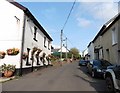
Cheriton Fitzpaine : Village Road
Looking along a road heading through Cheriton Fitzpaine.
Image: © Lewis Clarke
Taken: 12 Mar 2017
0.06 miles
3
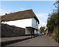
Thatched long-house, Cheriton Fitzpaine
Image: © Roger Cornfoot
Taken: 6 Sep 2017
0.06 miles
4
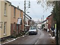
Village street, Cheriton Fitzpaine
The main street passes the post office on the right.
Image: © Derek Harper
Taken: 3 Dec 2010
0.06 miles
5

Cheriton Fitzpaine: churchyard
A corner of the yard, looking east with gravestones representing members of the Melhuish and Bradford families, amongst others
Image: © Martin Bodman
Taken: 7 Oct 2006
0.07 miles
6
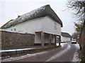
Cheriton Primary School
"This is thought to be the longest thatch-roofed building in Gt Britain" http://www.britishlistedbuildings.co.uk/en-96471-cheriton-primary-school-cheriton-fitzpain , extending across the pavement and suported by timber posts. Formerly a church house / poorhouse, it was converted to a school in the C20. But the school has just moved to a new building at the east end of the village, and this listed structure is now for sale.
Image: © Derek Harper
Taken: 3 Dec 2010
0.07 miles
7

Cheriton Fitzpaine : Village Road
A road alongside the Ring of Bells in Cheriton Fitzpaine.
Image: © Lewis Clarke
Taken: 25 Mar 2016
0.07 miles
8
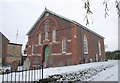
Chapel, Cheriton Fitzpaine
In red stone and redder brick, the Bible Christian chapel (now the Methodist church), dating from 1887, is on the north side of the village street shown in Image
Image: © Derek Harper
Taken: 3 Dec 2010
0.07 miles
9
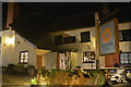
Cheriton Fitzpaine : The Ring of Bells
The Ring of Bells is a Grade II listed pub which has been serving the community for centuries.
Image: © Lewis Clarke
Taken: 25 Mar 2016
0.08 miles