IMAGES TAKEN NEAR TO
Coppice Lane, CREDITON, EX17 4EG
Introduction
This page details the photographs taken nearby to Coppice Lane, EX17 4EG by members of the Geograph project.
The Geograph project started in 2005 with the aim of publishing, organising and preserving representative images for every square kilometre of Great Britain, Ireland and the Isle of Man.

There are currently over 7.5m images from over14,400 individuals and you can help contribute to the project by visiting https://www.geograph.org.uk
Image Map
Images are licensed for reuse under creativecommons.org/licenses/by-sa/2.0
Notes
- Clicking on the map will re-center to the selected point.
- The higher the marker number, the further away the image location is from the centre of the postcode.
Image Listing (23 Images Found)
Images are licensed for reuse under creativecommons.org/licenses/by-sa/2.0
Image
Details
Distance
1

Sandford : Creedy Nook
Looking towards Creedy Nook on Coppice Lane.
Image: © Lewis Clarke
Taken: 9 May 2020
0.02 miles
2
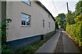
Sandford : Coppice Lane
Looking along Coppice Lane passing Pixie Cottage.
Image: © Lewis Clarke
Taken: 9 May 2020
0.03 miles
3

Valley of Binneford Water
Looking towards Windmill Hill
Image: © David Smith
Taken: 11 Jul 2018
0.04 miles
4

Sandford : Grassy Field
Looking across a grassy field with some sheep in.
Image: © Lewis Clarke
Taken: 9 May 2020
0.04 miles
5

Binneford Water west of Dowrich Bridge
Looking upstream
Image: © David Smith
Taken: 11 Jul 2018
0.11 miles
6

Sandford : Grassy Field
Looking out across a grassy field.
Image: © Lewis Clarke
Taken: 9 May 2020
0.12 miles
7

Sandford : Binneford Water
Looking along the stream passing through the Sandford parish.
Image: © Lewis Clarke
Taken: 9 May 2020
0.12 miles
8

Binneford Water
The stream seen looking upstream from Dowrich Bridge, with daffodils on the banks.
Image: © Derek Harper
Taken: 16 Mar 2011
0.12 miles
9

Sandford : Country Lane
A country lane heading through the parish of Sandford.
Image: © Lewis Clarke
Taken: 9 May 2020
0.13 miles
10
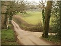
Junction near Dowrich Bridge
Taken from Dowrich Bridge across Binneford Water. The right turn leads through Aller Down; straight ahead is for Sandford.
Image: © Derek Harper
Taken: 16 Mar 2011
0.13 miles