IMAGES TAKEN NEAR TO
EX17 4DR
Introduction
This page details the photographs taken nearby to EX17 4DR by members of the Geograph project.
The Geograph project started in 2005 with the aim of publishing, organising and preserving representative images for every square kilometre of Great Britain, Ireland and the Isle of Man.

There are currently over 7.5m images from over14,400 individuals and you can help contribute to the project by visiting https://www.geograph.org.uk
Image Map
Images are licensed for reuse under creativecommons.org/licenses/by-sa/2.0
Notes
- Clicking on the map will re-center to the selected point.
- The higher the marker number, the further away the image location is from the centre of the postcode.
Image Listing (5 Images Found)
Images are licensed for reuse under creativecommons.org/licenses/by-sa/2.0
Image
Details
Distance
1
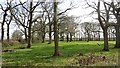
Remains of a woodland
Some big trees still stand, but this is now a field, the understory long gone.
Image: © Richard Webb
Taken: 2 Apr 2012
0.19 miles
2

Mid Devon : Track
A track heading towards HMF Equestrian.
Image: © Lewis Clarke
Taken: 28 Nov 2017
0.20 miles
3
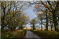
Mid Devon : Country Lane
A small lane heading through the Mid Devon countryside.
Image: © Lewis Clarke
Taken: 28 Nov 2017
0.21 miles

5
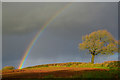
Mid Devon : Grassy Field
A rainbow in the sky in the Mid Devon countryside.
Image: © Lewis Clarke
Taken: 28 Nov 2017
0.24 miles