IMAGES TAKEN NEAR TO
Voysey Hill, CREDITON, EX17 4AL
Introduction
This page details the photographs taken nearby to Voysey Hill, EX17 4AL by members of the Geograph project.
The Geograph project started in 2005 with the aim of publishing, organising and preserving representative images for every square kilometre of Great Britain, Ireland and the Isle of Man.

There are currently over 7.5m images from over14,400 individuals and you can help contribute to the project by visiting https://www.geograph.org.uk
Image Map
Images are licensed for reuse under creativecommons.org/licenses/by-sa/2.0
Notes
- Clicking on the map will re-center to the selected point.
- The higher the marker number, the further away the image location is from the centre of the postcode.
Image Listing (4 Images Found)
Images are licensed for reuse under creativecommons.org/licenses/by-sa/2.0
Image
Details
Distance
1
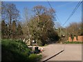
Chapel Hill Cross
At this junction is a bridge over Wilson's Water. Voysey Hill (foreground) meets White Rose Hill (right); the road continues as Chapel Hill.
Image: © Derek Harper
Taken: 22 Apr 2010
0.05 miles
2
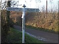
Chapel Hill Cross at Wilson Water
The junction at the foot of Chapel Hill is marked on the OS map as Chapel Hill Cross, but the sign is labelled Wilson Water as the junction is where Chapel Hill crosses the stream Wilson's Water
Image: © David Smith
Taken: 13 Dec 2012
0.05 miles
3
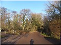
Woodland by Wilson's Water
The stream runs through the woodland and is bridged by Chapel Hill on the right.
Image: © David Smith
Taken: 13 Dec 2012
0.05 miles
4
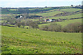
Cheriton Fitzpaine: near Redyeates Farm
Looking west-north-west towards Leys Farm, with Marsh Farm, beyond left and Coddiford, extreme left, all beyond the square
Image: © Martin Bodman
Taken: 13 Mar 2007
0.24 miles