IMAGES TAKEN NEAR TO
Shobrooke, CREDITON, EX17 4AJ
Introduction
This page details the photographs taken nearby to EX17 4AJ by members of the Geograph project.
The Geograph project started in 2005 with the aim of publishing, organising and preserving representative images for every square kilometre of Great Britain, Ireland and the Isle of Man.

There are currently over 7.5m images from over14,400 individuals and you can help contribute to the project by visiting https://www.geograph.org.uk
Image Map
Images are licensed for reuse under creativecommons.org/licenses/by-sa/2.0
Notes
- Clicking on the map will re-center to the selected point.
- The higher the marker number, the further away the image location is from the centre of the postcode.
Image Listing (13 Images Found)
Images are licensed for reuse under creativecommons.org/licenses/by-sa/2.0
Image
Details
Distance
1
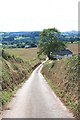
Minor road from Higher Haske Cross to Nomansland
A minor road running from Higher Haske Cross, near Creedy Bridge, east towards Nomansland. Eclipsed by the turnpike a little to the south (now the A3072), the lane seems likely to have been a more important route pre-turnpike, with only a footpath now continuing the route eastwards across the fields to Great Gutton.
Image: © Hugh Craddock
Taken: 23 Jul 2011
0.13 miles
2
Shobrooke: towards Bradley Farm
Looking west-north-west near Nomansland
Image: © Martin Bodman
Taken: 13 Aug 2006
0.14 miles
4
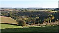
Hillside near Bradley
A steep hillside reverting to woodland above Great Gutton, and seen from the lane between Cheriton Cross and Nomansland.
Image: © Derek Harper
Taken: 25 Oct 2010
0.15 miles
5
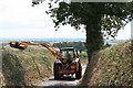
Shobrooke: trimming a roadside hedgebank
Looking south-south-east on the lane from Broxford Cross to Shobrooke
Image: © Martin Bodman
Taken: 13 Aug 2006
0.17 miles
7
Shobrooke: footpath to Great Gutton
Looking east-north-east
Image: © Martin Bodman
Taken: 13 Aug 2006
0.19 miles
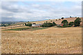
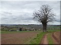
8
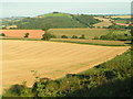
Fields near Bradley Farm, Raddon Hills in the background
Image: © Rob Purvis
Taken: 21 Sep 2008
0.19 miles
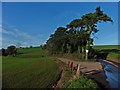
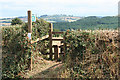
9
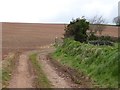
Track from Haske to Bradley Farm
A notice at the corner in the track points out that the right of way has been diverted. Formerly it ran straight ahead, following a field boundary, now removed
Image: © David Smith
Taken: 8 Apr 2016
0.24 miles