IMAGES TAKEN NEAR TO
CREDITON, EX17 3PX
Introduction
This page details the photographs taken nearby to EX17 3PX by members of the Geograph project.
The Geograph project started in 2005 with the aim of publishing, organising and preserving representative images for every square kilometre of Great Britain, Ireland and the Isle of Man.

There are currently over 7.5m images from over14,400 individuals and you can help contribute to the project by visiting https://www.geograph.org.uk
Image Map
Images are licensed for reuse under creativecommons.org/licenses/by-sa/2.0
Notes
- Clicking on the map will re-center to the selected point.
- The higher the marker number, the further away the image location is from the centre of the postcode.
Image Listing (6 Images Found)
Images are licensed for reuse under creativecommons.org/licenses/by-sa/2.0
Image
Details
Distance

2
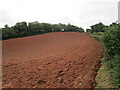
Red earth and Fordton Down Coppice
Image: © Jonathan Thacker
Taken: 25 Sep 2021
0.05 miles

6
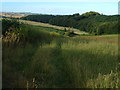
Fordton Down Copse
Looking towards the copse from the lane between Fordton Cross and Eastacott, near Broomfield. The valley leads to the River Yeo valley.
Image: © Derek Harper
Taken: 11 Jul 2006
0.16 miles