IMAGES TAKEN NEAR TO
Threshers, CREDITON, EX17 3NN
Introduction
This page details the photographs taken nearby to Threshers, EX17 3NN by members of the Geograph project.
The Geograph project started in 2005 with the aim of publishing, organising and preserving representative images for every square kilometre of Great Britain, Ireland and the Isle of Man.

There are currently over 7.5m images from over14,400 individuals and you can help contribute to the project by visiting https://www.geograph.org.uk
Image Map
Images are licensed for reuse under creativecommons.org/licenses/by-sa/2.0
Notes
- Clicking on the map will re-center to the selected point.
- The higher the marker number, the further away the image location is from the centre of the postcode.
Image Listing (39 Images Found)
Images are licensed for reuse under creativecommons.org/licenses/by-sa/2.0
Image
Details
Distance
1
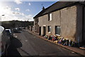
Crediton : Threshers
The area known as Threshers in Crediton.
Image: © Lewis Clarke
Taken: 2 Mar 2015
0.02 miles
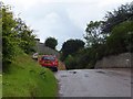
2
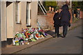
Crediton : Threshers
Threshers in Crediton with flowers on the side of the road following a fatal accident.
Image: © Lewis Clarke
Taken: 2 Mar 2015
0.03 miles
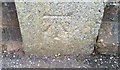
3
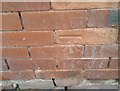
Ordnance Survey Cut Mark
This OS cut mark can be found on No3 Threshers. It marks a point 82.116m above mean sea level.
Image: © Adrian Dust
Taken: 31 Mar 2019
0.06 miles
4
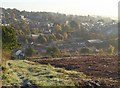
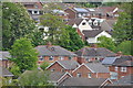
Crediton from Pitt Hill
A detailed view of Image, looking across Threshers and the grounds of the hospital, with the buildings of Queen Elizabeth's Community College at upper left.
Image: © Derek Harper
Taken: 25 Oct 2010
0.08 miles
5
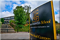
Crediton : Queen Elizabeth's School
Queen Elizabeth's School is an academy school in Crediton, Devon.It is Devon's only state boarding school, and serves over 1600 students, of whom around one in forty are boarders.
Image: © Lewis Clarke
Taken: 21 Jul 2018
0.09 miles
6
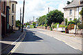
Western road, Crediton
A377 heading west.
Image: © J.Hannan-Briggs
Taken: 20 Jul 2017
0.09 miles
8
Ordnance Survey Cut Mark
This OS cut mark can be found on the school wall, Landscore. It marks a point 84.744m above mean sea level.
Image: © Adrian Dust
Taken: 31 Mar 2019
0.09 miles
9
Crediton : Town Scenery
Looking across the rooftops of houses in Crediton.
Image: © Lewis Clarke
Taken: 17 May 2015
0.10 miles
10
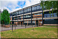
Crediton : Queen Elizabeth's School
Queen Elizabeth's School is an academy school in Crediton, Devon.It is Devon's only state boarding school, and serves over 1600 students, of whom around one in forty are boarders.
Image: © Lewis Clarke
Taken: 21 Jul 2018
0.10 miles