IMAGES TAKEN NEAR TO
Greenway, CREDITON, EX17 3LP
Introduction
This page details the photographs taken nearby to Greenway, EX17 3LP by members of the Geograph project.
The Geograph project started in 2005 with the aim of publishing, organising and preserving representative images for every square kilometre of Great Britain, Ireland and the Isle of Man.

There are currently over 7.5m images from over14,400 individuals and you can help contribute to the project by visiting https://www.geograph.org.uk
Image Map
Images are licensed for reuse under creativecommons.org/licenses/by-sa/2.0
Notes
- Clicking on the map will re-center to the selected point.
- The higher the marker number, the further away the image location is from the centre of the postcode.
Image Listing (55 Images Found)
Images are licensed for reuse under creativecommons.org/licenses/by-sa/2.0
Image
Details
Distance
1

Back lane, Crediton
Crediton Footpath 1 runs along this back lane between the High Street and Greenway.
Image: © Derek Harper
Taken: 25 Oct 2010
0.06 miles
2

High Street, Crediton
The A377 leaving town. Shortly after I took this, one of the local neds threw a stick of mascara at me.
Image: © Richard Webb
Taken: 2 Apr 2012
0.07 miles
3

Crediton: 100 High Street
‘The Book Shop’ on the right was once the drive through to the tannery yard at the rear of the premises; one of three tanneries in 19th century Crediton. The works finally closed in 1964. On the left can be seen the entrance to the Congregational Chapel
Image: © Martin Bodman
Taken: 20 Feb 2005
0.07 miles
4
Crediton : High Street A377
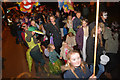
Looking along the A377 as the parade heads through the town.
Image: © Lewis Clarke
Taken: 27 Nov 2015
0.08 miles
5
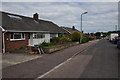
Crediton : Greenway
A small residential road in the Crediton outskirts.
Image: © Lewis Clarke
Taken: 17 May 2015
0.08 miles
6
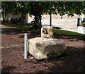
Old Wayside Cross by the A377, St Laurence's Green, Crediton
St Laurence's Green Cross, old shaft and base by the A377, in parish of Crediton (Mid Devon District), St Laurence's Green, in a flower bed within park area.
Grade II Listed. List Entry Number: 1292584
https://historicengland.org.uk/listing/the-list/list-entry/1292584
Surveyed
Milestone Society National ID: DVMD_CRE01.
Image: © Alan Rosevear
Taken: 20 May 2009
0.10 miles
7
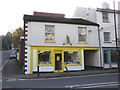
The Yellow Book Shop, High Street, Crediton
A charity shop, run by the local Liberal Democrat party.
Image: © Roger Cornfoot
Taken: 9 Nov 2009
0.10 miles
8

Crediton : Town Scenery
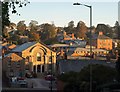
Looking across the Crediton suburbs.
Image: © Lewis Clarke
Taken: 17 May 2015
0.11 miles
9
Crediton
A view of part of the western town centre from St Saviour's Way. On the left is Image The square brick building on the right, on Searle Street, is in Image
Image: © Derek Harper
Taken: 25 Oct 2010
0.11 miles
10
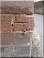
Ordnance Survey Cut Mark
This OS cut mark can be found on No97 High Street. A Hair & Beauty Shop. It marks a point 69.030m above mean sea level.
Image: © Adrian Dust
Taken: 24 Apr 2015
0.11 miles