
IMAGES TAKEN NEAR TO
Mill Street, CREDITON, EX17 3FQ
Introduction
This page details the photographs taken nearby to Mill Street, EX17 3FQ by members of the Geograph project.
The Geograph project started in 2005 with the aim of publishing, organising and preserving representative images for every square kilometre of Great Britain, Ireland and the Isle of Man.

There are currently over 7.5m images from over14,400 individuals and you can help contribute to the project by visiting https://www.geograph.org.uk
Image Map
Images are licensed for reuse under creativecommons.org/licenses/by-sa/2.0
Notes
- Clicking on the map will re-center to the selected point.
- The higher the marker number, the further away the image location is from the centre of the postcode.
Image Listing (155 Images Found)
Images are licensed for reuse under creativecommons.org/licenses/by-sa/2.0
Image
Details
Distance
1

Crediton: former Exeter Road Post Office and postbox № EX17 68
This post office closed in 2008, leaving the main branch as the only office in the town. The postbox incorporated in the window has been taken out of service and replaced by a modern box to the left, emptied finally at 5:45pm on weekdays and at noon on Saturdays.
Image: © Chris Downer
Taken: 22 Aug 2009
0.01 miles
2

Crediton: redundant postbox in Exeter Road
A close-up of the postbox set within the window of Exeter Road Post Office, which closed in 2008. The box has been replaced by a modern one a short distance away – see Image
Image: © Chris Downer
Taken: 22 Aug 2009
0.01 miles

4

Crediton : Charlotte Street, A377
A road heading through the centre of Crediton.
Image: © Lewis Clarke
Taken: 30 Jul 2016
0.02 miles
5

Crediton : Mill Street, A3072
Mill Street in Crediton.
Image: © Lewis Clarke
Taken: 30 Jul 2016
0.02 miles
6
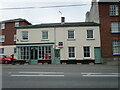
3 Exeter Road, Crediton
Built in the late eighteenth century. A former Post Office. https://historicengland.org.uk/listing/the-list/list-entry/1297272?section=official-listing
Image: © Jonathan Thacker
Taken: 25 Sep 2021
0.03 miles

8
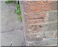
Ordnance Survey Cut Mark
This OS cut mark can be found on No10 Charlotte Street. It marks a point 54.690m above mean sea level.
Image: © Adrian Dust
Taken: 31 Mar 2019
0.04 miles
9

Terraced cottages, Charlotte Street, Crediton
Image: © Jonathan Thacker
Taken: 25 Sep 2021
0.04 miles
10
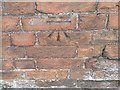
Ordnance Survey Cut Mark
This OS cut mark can be found on a building at Culver House, NE side of the road. It marks a point 55.595m above mean sea level.
Image: © Adrian Dust
Taken: 31 Mar 2019
0.05 miles