IMAGES TAKEN NEAR TO
Kirton Drive, CREDITON, EX17 3DW
Introduction
This page details the photographs taken nearby to Kirton Drive, EX17 3DW by members of the Geograph project.
The Geograph project started in 2005 with the aim of publishing, organising and preserving representative images for every square kilometre of Great Britain, Ireland and the Isle of Man.

There are currently over 7.5m images from over14,400 individuals and you can help contribute to the project by visiting https://www.geograph.org.uk
Image Map
Images are licensed for reuse under creativecommons.org/licenses/by-sa/2.0
Notes
- Clicking on the map will re-center to the selected point.
- The higher the marker number, the further away the image location is from the centre of the postcode.
Image Listing (92 Images Found)
Images are licensed for reuse under creativecommons.org/licenses/by-sa/2.0
Image
Details
Distance
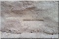
2
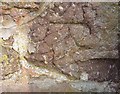
Ordnance Survey Cut Mark
This OS cut mark can be found on wall north side of Park Road at the junction with Dean Street. It marks a point 60.418m above mean sea level.
Image: © Adrian Dust
Taken: 31 Mar 2019
0.10 miles

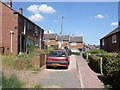
4

Crediton : Exeter Road, A377
Looking along Exeter Road as it heads out from Crediton.
Image: © Lewis Clarke
Taken: 30 Jul 2016
0.12 miles
5
Crediton : St Boniface Catholic Church
A church located on Park Road in Crediton.
Image: © Lewis Clarke
Taken: 4 Jun 2015
0.12 miles
6
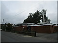
St. Boniface Roman Catholic church, Crediton
St. Boniface https://en.wikipedia.org/wiki/Saint_Boniface was born in Crediton c675 and this church is the national shrine.
Image: © Jonathan Thacker
Taken: 25 Sep 2021
0.12 miles
7
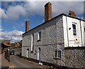
House on Four Mills Lane, Crediton
The early Victorian 31 Exeter Road http://www.imagesofengland.org.uk/details/default.aspx?id=386991 occupies the angle between Four Mills Lane and the main road, seen on the left climbing into the town.
Image: © Derek Harper
Taken: 6 Mar 2010
0.12 miles
8
Ordnance Survey Cut Mark
This OS cut mark can be found on the wall east side of the road. It marks a point 50.334m above mean sea level.
Image: © Adrian Dust
Taken: 31 Mar 2019
0.13 miles
9

Commercial buildings, Exeter Road, Crediton
These are very shallow buildings, backed by the wall that is visible at the left of the picture
Image: © David Smith
Taken: 20 Feb 2019
0.13 miles
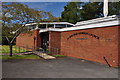
10

Crediton: Catholic church of St. Boniface
A modern church building in Ford Road.
Image: © Chris Downer
Taken: 22 Aug 2009
0.14 miles