IMAGES TAKEN NEAR TO
East Street, CREDITON, EX17 3AX
Introduction
This page details the photographs taken nearby to East Street, EX17 3AX by members of the Geograph project.
The Geograph project started in 2005 with the aim of publishing, organising and preserving representative images for every square kilometre of Great Britain, Ireland and the Isle of Man.

There are currently over 7.5m images from over14,400 individuals and you can help contribute to the project by visiting https://www.geograph.org.uk
Image Map
Images are licensed for reuse under creativecommons.org/licenses/by-sa/2.0
Notes
- Clicking on the map will re-center to the selected point.
- The higher the marker number, the further away the image location is from the centre of the postcode.
Image Listing (174 Images Found)
Images are licensed for reuse under creativecommons.org/licenses/by-sa/2.0
Image
Details
Distance
1
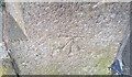
Ordnance Survey Cut Mark
This OS cut mark can be found on the gatepost of Haywards West, East Street. It marks a point 54.827m above mean sea level.
Image: © Adrian Dust
Taken: 31 Mar 2019
0.00 miles
2
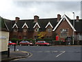
Crediton - almshouses and the junction of Church Lane with the A377
Image: © Ruth Sharville
Taken: 21 Oct 2009
0.01 miles
3
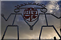
Crediton : Haywards Primary School
Looking up to the logo and sign outside Haywards Primary School.
Image: © Lewis Clarke
Taken: 13 Nov 2015
0.01 miles
4
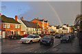
Crediton : East Street
Looking along East Street in Crediton.
Image: © Lewis Clarke
Taken: 13 Nov 2015
0.01 miles
5
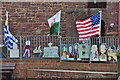
Crediton : Haywards Primary School
Flags and decorations at the entrance to the primary school.
Image: © Lewis Clarke
Taken: 16 Sep 2015
0.03 miles
6
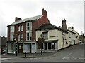
The corner of East Street and Dean Street, Crediton
The building on the corner dates from the late seventeenth century but is much altered https://historicengland.org.uk/listing/the-list/list-entry/1208412
Image: © Jonathan Thacker
Taken: 17 Sep 2018
0.03 miles
7

Building with Art Deco leanings, East Street, Crediton
Image: © Jonathan Thacker
Taken: 25 Sep 2021
0.03 miles
8
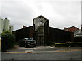
The Boniface Centre, Crediton
Parish church centre named after Boniface, Apostle of the Germans, who was born in Crediton in about 675 https://en.wikipedia.org/wiki/Saint_Boniface
Image: © Jonathan Thacker
Taken: 17 Sep 2018
0.04 miles
9
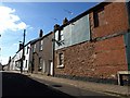
Dean Street, Crediton
On the right is the listed number 1, Bowden Hill, and this wall comes in for a very detailed description: "The 2-window Dean Street elevation has been stripped of plaster except for a section to the first floor left. Stone rubble to the left with a straight joint then brickwork to the right - stretcher bond to the ground floor, Flemish bond above with a large trimmer beam at first floor level and smaller timber lacing below. One ground and one first floor circa mid C19 12-pane sash to the left, the ground floor window with a timber lintel. Blind window to first floor right, also with a timber lintel" http://www.imagesofengland.org.uk/Details/Default.aspx?id=386958&mode=adv .
Image: © Derek Harper
Taken: 6 Mar 2010
0.04 miles
10

Ordnance Survey Rivet
This OS rivet can be found on the entrance step to the church yard. It marks a point 57.958m above mean sea level.
Image: © Adrian Dust
Taken: 31 Mar 2019
0.04 miles