IMAGES TAKEN NEAR TO
High Street, CREDITON, EX17 3AB
Introduction
This page details the photographs taken nearby to High Street, EX17 3AB by members of the Geograph project.
The Geograph project started in 2005 with the aim of publishing, organising and preserving representative images for every square kilometre of Great Britain, Ireland and the Isle of Man.

There are currently over 7.5m images from over14,400 individuals and you can help contribute to the project by visiting https://www.geograph.org.uk
Image Map
Images are licensed for reuse under creativecommons.org/licenses/by-sa/2.0
Notes
- Clicking on the map will re-center to the selected point.
- The higher the marker number, the further away the image location is from the centre of the postcode.
Image Listing (169 Images Found)
Images are licensed for reuse under creativecommons.org/licenses/by-sa/2.0
Image
Details
Distance
1
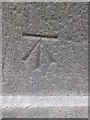
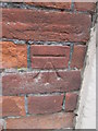
Ordnance Survey Cut Mark
This OS cut mark can be found on the post on the south side of Union Road. It marks a point 64.103m above mean sea level.
Image: © Adrian Dust
Taken: 24 Apr 2015
0.01 miles
3
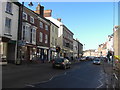
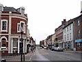
Crediton: High Street 3
By the North Street turning, looking west-north-west. Two shopfronts beyond Costcutter is the Market Street turning, just in front of the Ship Inn
Image: © Martin Bodman
Taken: 8 Sep 2008
0.02 miles
4

Crediton old fire station
Crediton old fire station, North Street, Crediton, Devon, now converted into The Old Fire Station Steak House
Image: © Kevin Hale
Taken: 27 Jun 2010
0.03 miles
5

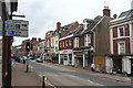
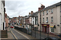
Crediton : High Street
Crediton High Street offers a place to buy things in shops such as Helmores, Bradleys and Adams Home Hardware.
Image: © Lewis Clarke
Taken: 13 Feb 2008
0.04 miles
6
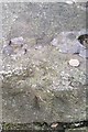
Ordnance Survey Rivet
This OS rivet can be found on the step of No1 Union Terrace. It marks a point 70.531m above mean sea level.
Image: © Adrian Dust
Taken: 31 Mar 2019
0.04 miles
7
Crediton High Street
About 100 years after Frith's original photograph (52085) of the same scene in 1904.
Image: © S J Dowden
Taken: 30 Oct 2008
0.05 miles
8
Crediton: Union Road from Union Terrace
Where Union Road and Terrace junction, the main road continues as Crediton High Street. The turning on the right, past the building with a pediment, is North Street
Image: © Martin Bodman
Taken: 8 Sep 2008
0.05 miles
9
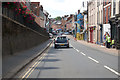
Union Road, Crediton
The A377 runs through the town.
Image: © J.Hannan-Briggs
Taken: 20 Jul 2017
0.05 miles
10
Ordnance Survey Cut Mark
This OS cut mark can be found on the National Westminster Bank, High Street. It marks a point 66.792m above mean sea level.
Image: © Adrian Dust
Taken: 24 Apr 2015
0.05 miles