IMAGES TAKEN NEAR TO
Jockey Hill, CREDITON, EX17 2FA
Introduction
This page details the photographs taken nearby to Jockey Hill, EX17 2FA by members of the Geograph project.
The Geograph project started in 2005 with the aim of publishing, organising and preserving representative images for every square kilometre of Great Britain, Ireland and the Isle of Man.

There are currently over 7.5m images from over14,400 individuals and you can help contribute to the project by visiting https://www.geograph.org.uk
Image Map
Images are licensed for reuse under creativecommons.org/licenses/by-sa/2.0
Notes
- Clicking on the map will re-center to the selected point.
- The higher the marker number, the further away the image location is from the centre of the postcode.
Image Listing (129 Images Found)
Images are licensed for reuse under creativecommons.org/licenses/by-sa/2.0
Image
Details
Distance
1

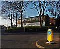
Crediton, Holy Cross Church: The Tuckfield monument and tomb of Sir William Peryam
Image: © Michael Garlick
Taken: 9 Aug 2023
0.05 miles
2

Pink doors, Crediton
An enviable pair of garage doors at the junction of Jockey Hill (left) and Pounds Hill.
Image: © Derek Harper
Taken: 25 Oct 2010
0.07 miles

5
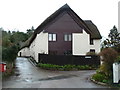
Former maltings - Crediton
Thatched maltings now converted to dwellings. These are relatively inconspicuous and I only found them after a local pointed me in this direction.
Image: © Chris Allen
Taken: 24 Dec 2012
0.10 miles
6
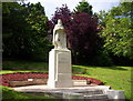
St Boniface Statue Crediton
Statue of St Boniface The destroyer of Oak Groves.
Image: © Michael Murray
Taken: 12 Jun 2005
0.15 miles
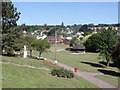
8
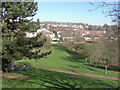
Crediton : Newcombe's Meadow
A grassy area for the people of Crediton to enjoy.
Image: © Lewis Clarke
Taken: 13 Feb 2008
0.17 miles
9
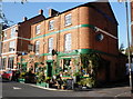
The Three Little Pigs, Parliament Square, Crediton
Image: © Roger Cornfoot
Taken: 9 Nov 2009
0.18 miles
10
Ordnance Survey Cut Mark
This OS cut mark can be found on the Church yard wall, Church Street. It marks a point 55.425m above mean sea level.
Image: © Adrian Dust
Taken: 31 Mar 2019
0.18 miles