IMAGES TAKEN NEAR TO
Monks Close, CREDITON, EX17 2EL
Introduction
This page details the photographs taken nearby to Monks Close, EX17 2EL by members of the Geograph project.
The Geograph project started in 2005 with the aim of publishing, organising and preserving representative images for every square kilometre of Great Britain, Ireland and the Isle of Man.

There are currently over 7.5m images from over14,400 individuals and you can help contribute to the project by visiting https://www.geograph.org.uk
Image Map
Images are licensed for reuse under creativecommons.org/licenses/by-sa/2.0
Notes
- Clicking on the map will re-center to the selected point.
- The higher the marker number, the further away the image location is from the centre of the postcode.
Image Listing (17 Images Found)
Images are licensed for reuse under creativecommons.org/licenses/by-sa/2.0
Image
Details
Distance
1

Crediton : St Lawrence Care Home
St Lawrence residential care home takes care of the elderly.
Image: © Lewis Clarke
Taken: 14 Feb 2008
0.15 miles
2
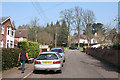
Crediton: Buller Road
Looking north-north-west. The Buller family lived at Downes, a mansion outside the town, from 1726. Its most famous son was Sir Redvers Buller, who relieved Ladysmith in 1900, in the Second Boer War. The town of Redvers in Canada is named after him
Image: © Martin Bodman
Taken: 27 Mar 2007
0.16 miles

4
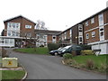
Crediton : St Lawrence Care Home
St Lawrence residential care home for elderly and is located on Churchill Drive.
Image: © Lewis Clarke
Taken: 14 Feb 2008
0.16 miles
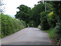
5

Seat, Long Plantation
At this point, the footpath shown in Image and Image swings sharply right. In the background is the road between Sandford and Crediton.
Image: © Derek Harper
Taken: 25 Oct 2010
0.19 miles
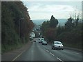
8
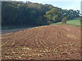
Stubble field, Long Plantation
Lines of stubble curving across a combe in this field between Long Plantation (rear) and the road between Sandford and Crediton.
Image: © Derek Harper
Taken: 25 Oct 2010
0.20 miles
9

Observation point, Crediton, Devon
This unusual seat is in a small area on the highest point to the north of Crediton. It has wrought iron lettering and arrows pointing at various places on the horizon. A plaque on the walled area refers to the gardens as "Upper Deck" (see supplementary picture).
Image: © Robin Lucas
Taken: 22 May 2007
0.22 miles
10

Crediton : Queen Elizabeth School
A side building to Crediton's Queen Elizabeth's School.
Image: © Lewis Clarke
Taken: 14 Feb 2008
0.23 miles