IMAGES TAKEN NEAR TO
Shobrooke Park, CREDITON, EX17 1DQ
Introduction
This page details the photographs taken nearby to EX17 1DQ by members of the Geograph project.
The Geograph project started in 2005 with the aim of publishing, organising and preserving representative images for every square kilometre of Great Britain, Ireland and the Isle of Man.

There are currently over 7.5m images from over14,400 individuals and you can help contribute to the project by visiting https://www.geograph.org.uk
Image Map
Images are licensed for reuse under creativecommons.org/licenses/by-sa/2.0
Notes
- Clicking on the map will re-center to the selected point.
- The higher the marker number, the further away the image location is from the centre of the postcode.
Image Listing (7 Images Found)
Images are licensed for reuse under creativecommons.org/licenses/by-sa/2.0
Image
Details
Distance
1
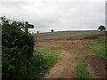
Footpath to Shobrooke
Crosses this field.
Image: © Jonathan Thacker
Taken: 25 Sep 2021
0.11 miles
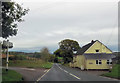
2
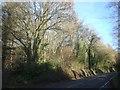
A3072 passing through woods near Shobrooke
Image: © David Smith
Taken: 13 Dec 2009
0.16 miles
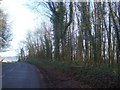
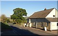
3
A3072 passing through woods near Shobrooke
Image: © David Smith
Taken: 13 Dec 2009
0.17 miles
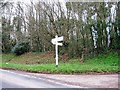
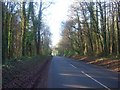
6
Nomansland
Nomansland Cottage is on the A3072 beside a staggered crossroads where the lane crosses between Cheriton Cross and Shobrooke. The notice, incidentally, advertises free range eggs and dairy produce.
Image: © Derek Harper
Taken: 25 Oct 2010
0.21 miles