IMAGES TAKEN NEAR TO
Oakford, TIVERTON, EX16 9HH
Introduction
This page details the photographs taken nearby to EX16 9HH by members of the Geograph project.
The Geograph project started in 2005 with the aim of publishing, organising and preserving representative images for every square kilometre of Great Britain, Ireland and the Isle of Man.

There are currently over 7.5m images from over14,400 individuals and you can help contribute to the project by visiting https://www.geograph.org.uk
Image Map
Images are licensed for reuse under creativecommons.org/licenses/by-sa/2.0
Notes
- Clicking on the map will re-center to the selected point.
- The higher the marker number, the further away the image location is from the centre of the postcode.
Image Listing (4 Images Found)
Images are licensed for reuse under creativecommons.org/licenses/by-sa/2.0
Image
Details
Distance

2
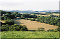
Oakford: towards East Tapps
Farmland and woodland, seen from the lane near Hutswell. Evening light. Bentley, the historian of Oakford, writing in the early 1980s, noted that a sluice gate and a millpond survived at East Tapps: the farm clearly used water power in the 19th century. In the 18th or earlier centuries a windmill seems to have existed on the estate. Fields here were known as ‘Windmill’ and ‘Outer Windmill’ in 1839.
Image: © Martin Bodman
Taken: 21 Aug 2005
0.17 miles
3
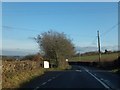
Turning for Harton and Harton Farm
The track on the left leads to several farms and houses. It is a public footpath, continuing a path from the opposite side of the B3227. The large white sign advertises logs for sale
Image: © David Smith
Taken: 9 Dec 2013
0.17 miles