IMAGES TAKEN NEAR TO
Nomansland, TIVERTON, EX16 8QS
Introduction
This page details the photographs taken nearby to EX16 8QS by members of the Geograph project.
The Geograph project started in 2005 with the aim of publishing, organising and preserving representative images for every square kilometre of Great Britain, Ireland and the Isle of Man.

There are currently over 7.5m images from over14,400 individuals and you can help contribute to the project by visiting https://www.geograph.org.uk
Image Map
Images are licensed for reuse under creativecommons.org/licenses/by-sa/2.0
Notes
- Clicking on the map will re-center to the selected point.
- The higher the marker number, the further away the image location is from the centre of the postcode.
Image Listing (19 Images Found)
Images are licensed for reuse under creativecommons.org/licenses/by-sa/2.0
Image
Details
Distance
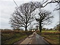
1

Mid Devon : South Looseland
Looking towards a house in Mid Devon.
Image: © Lewis Clarke
Taken: 29 Mar 2015
0.02 miles

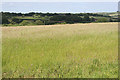
4
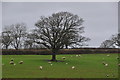
Mid Devon : Grassy Field
A grassy field in the Mid Devon countryside.
Image: © Lewis Clarke
Taken: 29 Mar 2015
0.12 miles
5
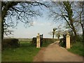
Gateposts, Kelly Lane
The rather grand entrance to Kelly Farm (another 700 metres down the lane) from the road across Looseland Moor.
Image: © Derek Harper
Taken: 19 Apr 2011
0.12 miles

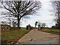
7

Mid Devon : Farm Track
A small farm track heading to Kelly Farms.
Image: © Lewis Clarke
Taken: 29 Mar 2015
0.12 miles
9
Cruwys Morchard: near Kelly
Looking east-north-east over farmland
Image: © Martin Bodman
Taken: 22 Jun 2006
0.13 miles
10

Mid Devon : Grassy Field
A gate provides entrance into the grassy field of sheep.
Image: © Lewis Clarke
Taken: 29 Mar 2015
0.13 miles