IMAGES TAKEN NEAR TO
Pennymoor, TIVERTON, EX16 8PQ
Introduction
This page details the photographs taken nearby to EX16 8PQ by members of the Geograph project.
The Geograph project started in 2005 with the aim of publishing, organising and preserving representative images for every square kilometre of Great Britain, Ireland and the Isle of Man.

There are currently over 7.5m images from over14,400 individuals and you can help contribute to the project by visiting https://www.geograph.org.uk
Image Map
Images are licensed for reuse under creativecommons.org/licenses/by-sa/2.0
Notes
- Clicking on the map will re-center to the selected point.
- The higher the marker number, the further away the image location is from the centre of the postcode.
Image Listing (1 Images Found)
Images are licensed for reuse under creativecommons.org/licenses/by-sa/2.0
Image
Details
Distance
1
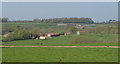
Farm buildings at Furze
A view from the lane between Pennymoor and Puddington, showing farms around the headwaters of Binneford Water. The nearer is Furze, the further, Merrifieldhayes, is largely in Image Beyond this is Two Post Plantation.
Image: © Derek Harper
Taken: 19 Apr 2011
0.12 miles