IMAGES TAKEN NEAR TO
Rackenford, TIVERTON, EX16 8EF
Introduction
This page details the photographs taken nearby to EX16 8EF by members of the Geograph project.
The Geograph project started in 2005 with the aim of publishing, organising and preserving representative images for every square kilometre of Great Britain, Ireland and the Isle of Man.

There are currently over 7.5m images from over14,400 individuals and you can help contribute to the project by visiting https://www.geograph.org.uk
Image Map (13 Images)


Getting Data...Please wait
Leaflet Map data © OpenStreetMap
Images are licensed for reuse under creativecommons.org/licenses/by-sa/2.0
Notes
- Clicking on the map will re-center to the selected point.
- The higher the marker number, the further away the image location is from the centre of the postcode.
Image Listing (13 Images Found)
Images are licensed for reuse under creativecommons.org/licenses/by-sa/2.0
Image
Details
Distance
2
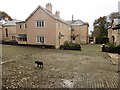
Rackenford: Rackenford Manor
A rare glimpse through the gateway of this private residence. Earlier known as Cruwyshaye, it stands on the site of an older manor house. Looking south-south-west
Image: © Martin Bodman
Taken: 6 Sep 2006
0.02 miles
5
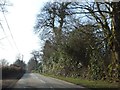
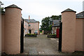
Road passing Rackenford Manor
A track on the left gives access to some of the estate, and the low hedge on the right forms the boundary of a further part
Image: © David Smith
Taken: 1 Mar 2012
0.21 miles
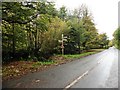
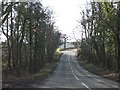
7
Road junction near Rackenford Manor
Image: © Sarah Charlesworth
Taken: 28 Oct 2009
0.23 miles
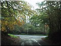
8
Approaching Knowstone Cross
A more distant view of the junction shown in Image taken from the same spot as Image, with Nine Acre Plantation on the left.
Image: © Derek Harper
Taken: 25 May 2011
0.23 miles
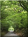
9
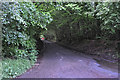
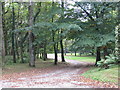
North Devon : Country Lane
A small lane heading underneath a canopy of trees in North Devon.
Image: © Lewis Clarke
Taken: 25 May 2014
0.23 miles
10

Old Direction Sign - Signpost by Knowstone Cross, Rackenford parish
Pyramid finial - 3 arms; Devon CC pyramid with name by the UC road (was A373), in parish of Rackenford (North Devon District), Knowstone Cross, restored.
Surveyed
Milestone Society National ID: DV_SS8419
Image: © John V Nicholls
Taken: 25 May 2007
0.23 miles