IMAGES TAKEN NEAR TO
Church Street, TIVERTON, EX16 8AP
Introduction
This page details the photographs taken nearby to Church Street, EX16 8AP by members of the Geograph project.
The Geograph project started in 2005 with the aim of publishing, organising and preserving representative images for every square kilometre of Great Britain, Ireland and the Isle of Man.

There are currently over 7.5m images from over14,400 individuals and you can help contribute to the project by visiting https://www.geograph.org.uk
Image Map
Images are licensed for reuse under creativecommons.org/licenses/by-sa/2.0
Notes
- Clicking on the map will re-center to the selected point.
- The higher the marker number, the further away the image location is from the centre of the postcode.
Image Listing (76 Images Found)
Images are licensed for reuse under creativecommons.org/licenses/by-sa/2.0
Image
Details
Distance
1

Witheridge : Offices and Workshops
Former school and school-house 29.12.75 now offices and workshop to Mole Valley Farmers GV II School. 2 datestones, to right gable face:- "1846" marking the date of first construction, to left:- "1898" marking the date of addition.
Image: © Lewis Clarke
Taken: 23 May 2012
0.01 miles
2
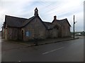
Former school, now workshops, Witheridge
The school-house is at the right, next to the entrance to the workshop area of Mole Valley Farmers. The gable still has the school bell, and the date 1846
Image: © David Smith
Taken: 10 Jan 2014
0.01 miles
3
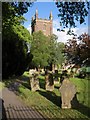
Churchyard, Witheridge
With gravestones and the tower of Image rising above the trees.
Image: © Derek Harper
Taken: 12 May 2011
0.02 miles
4
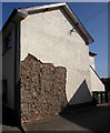
Unrendered wall, Witheridge
Revealing the rather more interesting rubble wall beneath. This is on Church Street.
Image: © Derek Harper
Taken: 17 Jul 2013
0.02 miles
5

Remains of the Old Toll House by the B3137, Witheridge
Toll House remains by the B3137, in parish of Witheridge (North Devon District), the remaining parts of the front wall of the tollhouse.
Surveyed
Milestone Society National ID: DV.WIT
Image: © Alan Rosevear
Taken: 21 Nov 2008
0.02 miles
6
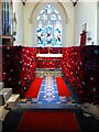
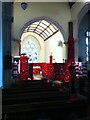
Church of St John the Baptist, Witheridge
A poppy display in the church.
Image: © Dave Hunt
Taken: 6 Nov 2018
0.03 miles
7

Approaching Witheridge
The lane from Witheridge reaches the B3137 at the northwest side of the village, with the Engineering Division of Mole Valley Farmers across the junction. On the left is the tower of Image
Image: © Derek Harper
Taken: 17 Jul 2013
0.03 miles
8
Church of St John the Baptist, Witheridge
A poppy display in the church.
Image: © Dave Hunt
Taken: 6 Nov 2018
0.03 miles
9
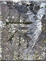
Ordnance Survey Cut Mark
This OS cut mark can be found on Saint John the Baptist Church. It marks a point 183.962m above mean sea level.
Image: © Adrian Dust
Taken: 18 Feb 2014
0.04 miles
10
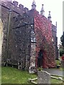
Church of St John the Baptist, Witheridge
A poppy display outside the church.
Image: © Dave Hunt
Taken: 6 Nov 2018
0.04 miles