IMAGES TAKEN NEAR TO
Cove, TIVERTON, EX16 7RR
Introduction
This page details the photographs taken nearby to EX16 7RR by members of the Geograph project.
The Geograph project started in 2005 with the aim of publishing, organising and preserving representative images for every square kilometre of Great Britain, Ireland and the Isle of Man.

There are currently over 7.5m images from over14,400 individuals and you can help contribute to the project by visiting https://www.geograph.org.uk
Image Map
Images are licensed for reuse under creativecommons.org/licenses/by-sa/2.0
Notes
- Clicking on the map will re-center to the selected point.
- The higher the marker number, the further away the image location is from the centre of the postcode.
Image Listing (74 Images Found)
Images are licensed for reuse under creativecommons.org/licenses/by-sa/2.0
Image
Details
Distance
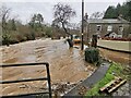
1
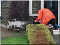
Tiverton : Cove - Mill House
People with buckets try to get rid of floodwater at Mill House.
Image: © Lewis Clarke
Taken: 12 Jan 2023
0.01 miles
2
Tiverton : Cove - Mill House
Mill House alongside Mill Leat.
Image: © Lewis Clarke
Taken: 12 Jan 2023
0.01 miles
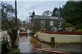
5
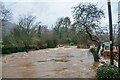
Tiverton : Cove - Mill Leat
Mill Leat has been flooded.
Image: © Lewis Clarke
Taken: 12 Jan 2023
0.01 miles
6
Tiverton : Cove - Mill Leat
Mill Leat has flooded.
Image: © Lewis Clarke
Taken: 12 Jan 2023
0.01 miles
7
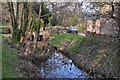
Cove : Mill Leat
Mill Leat running beside Mill House in Cove which flows close to the River Exe.
Image: © Lewis Clarke
Taken: 1 Mar 2012
0.02 miles
8
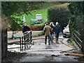
Tiverton : Cove - Road
A road across Mill Leat.
Image: © Lewis Clarke
Taken: 12 Jan 2023
0.03 miles
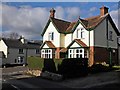
9
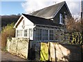
Former railway station building, Cove
Image: © Roger Cornfoot
Taken: 6 Feb 2013
0.03 miles
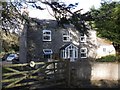
10
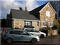
Cove siding cottage
Former railway building adjacent to the former GWR line from Tiverton to Dulverton.
Image: © Roger Cornfoot
Taken: 6 Feb 2013
0.03 miles