IMAGES TAKEN NEAR TO
Bolham, TIVERTON, EX16 7RL
Introduction
This page details the photographs taken nearby to EX16 7RL by members of the Geograph project.
The Geograph project started in 2005 with the aim of publishing, organising and preserving representative images for every square kilometre of Great Britain, Ireland and the Isle of Man.

There are currently over 7.5m images from over14,400 individuals and you can help contribute to the project by visiting https://www.geograph.org.uk
Image Map (Loading...)


Getting Data...Please wait
Leaflet Map data © OpenStreetMap
Images are licensed for reuse under creativecommons.org/licenses/by-sa/2.0
Notes
- Clicking on the map will re-center to the selected point.
- The higher the marker number, the further away the image location is from the centre of the postcode.
Image Listing (6 Images Found)
Images are licensed for reuse under creativecommons.org/licenses/by-sa/2.0
Image
Details
Distance
1
Orchard near Marley
A view from Tiverton Footpath 15 as it reaches Marley Cottages. Beyond the orchard is one of the short steep-sided combes that drops down the east side of the Exe valley, and which separates Marley Cottages from Marley.
Image: © Derek Harper
Taken: 8 Jul 2009
0.23 miles
2

The walled garden at Knightshayes Court
Image: © Sarah Charlesworth
Taken: 23 Oct 2011
0.23 miles
3

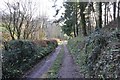
Hayne Lane
The lane, carrying Tiverton Footpath 15, passes Home Farm Cottage as it descends towards Bolham.
Image: © Derek Harper
Taken: 8 Jul 2009
0.24 miles
4
Mid Devon : Farm Track
A farm track which heads back down towards the A396 road.
Image: © Lewis Clarke
Taken: 5 Mar 2012
0.24 miles
5

Mid Devon : Layby on the A396
A layby on the A396 between Bolham and Cove.
Image: © Lewis Clarke
Taken: 5 Mar 2012
0.25 miles
6

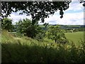
Looking south to Hayne, from Marley
Tiverton is visible in the bowl of land beyond.
Image: © Christopher Hilton
Taken: 18 Aug 2010
0.25 miles