IMAGES TAKEN NEAR TO
Chevithorne, TIVERTON, EX16 7QN
Introduction
This page details the photographs taken nearby to EX16 7QN by members of the Geograph project.
The Geograph project started in 2005 with the aim of publishing, organising and preserving representative images for every square kilometre of Great Britain, Ireland and the Isle of Man.

There are currently over 7.5m images from over14,400 individuals and you can help contribute to the project by visiting https://www.geograph.org.uk
Image Map
Images are licensed for reuse under creativecommons.org/licenses/by-sa/2.0
Notes
- Clicking on the map will re-center to the selected point.
- The higher the marker number, the further away the image location is from the centre of the postcode.
Image Listing (9 Images Found)
Images are licensed for reuse under creativecommons.org/licenses/by-sa/2.0
Image
Details
Distance
1
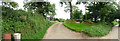
Mid Devon : Landrake Farm
Landrake Farm was farmed by the Kerslake family until 2000. They sell free range eggs here too according to the sign.
Image: © Lewis Clarke
Taken: 20 Jul 2008
0.07 miles
2
Tiverton: near Landrake
The old Tiverton – Bampton road looking north-north-east. A ridge road which at one time may well have linked the Roman forts at Bolham and Cudmore, near Clayhanger. Landrake Farm was run by the Kerslake family from 1919 to 2000 according to a notice by the entrance
Image: © Martin Bodman
Taken: 20 Jun 2006
0.09 miles
3

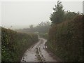
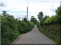
Mid Devon : Van Post Hill
Driving along the road towards Tiverton.
Image: © Lewis Clarke
Taken: 12 Apr 2009
0.14 miles
4

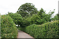
Mid Devon : Public Bridleway
A public bridleway to walk along and would make a lovely little countryside stroll.
Image: © Lewis Clarke
Taken: 20 Jul 2008
0.14 miles
5

Mid Devon : Rolling Hills of Devon
These are the green fields that make Devon a lovely place to live.
Image: © Lewis Clarke
Taken: 20 Jul 2008
0.17 miles
6
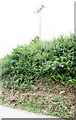
Gogwell Lane
This is Tiverton Bridleway 14, also seen in Image, starting its journey from Vanpost Hill. We're in cloud at 240 metres above sea level.
Image: © Derek Harper
Taken: 10 Oct 2012
0.17 miles
7

Houses on Gogwell Lane
The semis at Barton View are close to Vanpost Hill, the eastern end of the lane which carries Tiverton Bridleway 14.
Image: © Derek Harper
Taken: 10 Oct 2012
0.18 miles
9
Mid Devon : Van Post Hill
A road leading down Van Post Hill and into Tiverton - which is still quite a way.
Image: © Lewis Clarke
Taken: 20 Jul 2008
0.23 miles