IMAGES TAKEN NEAR TO
Clayhanger, TIVERTON, EX16 7NY
Introduction
This page details the photographs taken nearby to EX16 7NY by members of the Geograph project.
The Geograph project started in 2005 with the aim of publishing, organising and preserving representative images for every square kilometre of Great Britain, Ireland and the Isle of Man.

There are currently over 7.5m images from over14,400 individuals and you can help contribute to the project by visiting https://www.geograph.org.uk
Image Map (Loading...)


Getting Data...Please wait
Leaflet Map data © OpenStreetMap
Images are licensed for reuse under creativecommons.org/licenses/by-sa/2.0
Notes
- Clicking on the map will re-center to the selected point.
- The higher the marker number, the further away the image location is from the centre of the postcode.
Image Listing (15 Images Found)
Images are licensed for reuse under creativecommons.org/licenses/by-sa/2.0
Image
Details
Distance
2
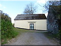
Clayhanger : Houses & Lane
Larcombe Cottage on the right with East Clayhanger Farm further down the lane.
Image: © Lewis Clarke
Taken: 6 Apr 2014
0.12 miles
3

Clayhanger : Public Footpath
A footpath heads away from the hamlet and out to the fields.
Image: © Lewis Clarke
Taken: 6 Apr 2014
0.13 miles
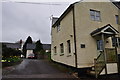
4

Clayhanger : Village Lane
A small lane heading into the small hamlet of Clayhanger.
Image: © Lewis Clarke
Taken: 6 Apr 2014
0.13 miles
5

Clayhanger : Village Lane
A small lane heading north and out of Clayhanger in Mid Devon.
Image: © Lewis Clarke
Taken: 6 Apr 2014
0.16 miles

8

Clayhanger : St Peter's Church
Parish church. West tower possibly C13, the fabric otherwise very rebuilt 1879-81
but window details suggest a C14 and earlier fabric. Local stone rubble; slate
roofs; C19 crested ridge tiles to nave and chancel.
Image: © Lewis Clarke
Taken: 6 Apr 2014
0.18 miles
9
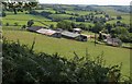
William's Farm
In the valley below the farm is the village of Clayhanger.
Image: © Derek Harper
Taken: 14 Jul 2011
0.19 miles
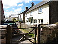
10

Clayhanger : Village Lane
A small lane heading beside the houses in Clayhanger.
Image: © Lewis Clarke
Taken: 6 Apr 2014
0.19 miles