IMAGES TAKEN NEAR TO
Huntsham, TIVERTON, EX16 7NB
Introduction
This page details the photographs taken nearby to EX16 7NB by members of the Geograph project.
The Geograph project started in 2005 with the aim of publishing, organising and preserving representative images for every square kilometre of Great Britain, Ireland and the Isle of Man.

There are currently over 7.5m images from over14,400 individuals and you can help contribute to the project by visiting https://www.geograph.org.uk
Image Map (Loading...)


Getting Data...Please wait
Leaflet Map data © OpenStreetMap
Images are licensed for reuse under creativecommons.org/licenses/by-sa/2.0
Notes
- Clicking on the map will re-center to the selected point.
- The higher the marker number, the further away the image location is from the centre of the postcode.
Image Listing (8 Images Found)
Images are licensed for reuse under creativecommons.org/licenses/by-sa/2.0
Image
Details
Distance
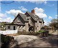
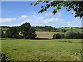
2

Huntsham: towards Venlake?s Farm
Looking south by the road from Huntsham to Three Gates Cross
Image: © Martin Bodman
Taken: 21 Jun 2006
0.02 miles
3

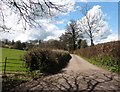
Lane to Huntsham
A sinuous stretch of lane along the upper Lowman valley.
Image: © Derek Harper
Taken: 3 Mar 2012
0.07 miles
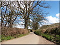
5
Valley of River Lowman north of Bidgood's Copse
Image: © David Smith
Taken: 31 Aug 2016
0.14 miles
6
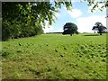
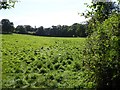
The edge of Bidgood's Copse
Field on the west side of the copse, with several pheasants startled by the prospect of being in a Geograph
Image: © David Smith
Taken: 31 Aug 2016
0.16 miles