IMAGES TAKEN NEAR TO
Burlescombe, TIVERTON, EX16 7JX
Introduction
This page details the photographs taken nearby to EX16 7JX by members of the Geograph project.
The Geograph project started in 2005 with the aim of publishing, organising and preserving representative images for every square kilometre of Great Britain, Ireland and the Isle of Man.

There are currently over 7.5m images from over14,400 individuals and you can help contribute to the project by visiting https://www.geograph.org.uk
Image Map
Images are licensed for reuse under creativecommons.org/licenses/by-sa/2.0
Notes
- Clicking on the map will re-center to the selected point.
- The higher the marker number, the further away the image location is from the centre of the postcode.
Image Listing (11 Images Found)
Images are licensed for reuse under creativecommons.org/licenses/by-sa/2.0
Image
Details
Distance

3

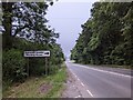
Mid Devon : The A38
The A38 heading through Mid Devon.
Image: © Lewis Clarke
Taken: 19 Nov 2015
0.12 miles

5

Mid Devon : The A38
The A38 between Junction 27 of the M5 and Wellington.
Image: © Lewis Clarke
Taken: 10 Jul 2012
0.15 miles
6

Mid Devon : Country Road
A country road heading towards the A38.
Image: © Lewis Clarke
Taken: 10 Jul 2012
0.17 miles
7
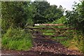
Mid Devon : Gate & Track
A gate with a track heading beyond it which is not for public access.
Image: © Lewis Clarke
Taken: 10 Jul 2012
0.19 miles
8

Mid Devon : Country Lane
A small country lane heading through Mid Devon.
Image: © Lewis Clarke
Taken: 19 Nov 2015
0.19 miles
9

Mid Devon : Grassy Field
A grassy field seen from the M5 motorway in Mid Devon.
Image: © Lewis Clarke
Taken: 15 Jun 2012
0.21 miles
10
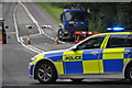
Mid Devon : The A38
The A38 following a fatal accident involving a motorcyclist.
Image: © Lewis Clarke
Taken: 27 Jul 2015
0.23 miles