IMAGES TAKEN NEAR TO
Uplowman, TIVERTON, EX16 7DR
Introduction
This page details the photographs taken nearby to EX16 7DR by members of the Geograph project.
The Geograph project started in 2005 with the aim of publishing, organising and preserving representative images for every square kilometre of Great Britain, Ireland and the Isle of Man.

There are currently over 7.5m images from over14,400 individuals and you can help contribute to the project by visiting https://www.geograph.org.uk
Image Map (Loading...)


Getting Data...Please wait
Leaflet Map data © OpenStreetMap
Images are licensed for reuse under creativecommons.org/licenses/by-sa/2.0
Notes
- Clicking on the map will re-center to the selected point.
- The higher the marker number, the further away the image location is from the centre of the postcode.
Image Listing (6 Images Found)
Images are licensed for reuse under creativecommons.org/licenses/by-sa/2.0
Image
Details
Distance
1
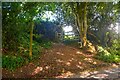
Uplowman : Footpath
A footpath heads off from the road and into the field.
Image: © Lewis Clarke
Taken: 31 May 2023
0.05 miles
2
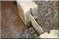
Uplowman: hatch
Hatch or control gate by the weir at the beginning of the Sampford Leat. A limited amount of water is allowed to run into the leat at present
Image: © Martin Bodman
Taken: 10 Apr 2010
0.13 miles
3
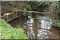
Uplowman: weir for Sampford Leat
With the hatches for the leat intake on the left. The Sampford Leat runs for 1.5 miles through Uplowman Cross to Higher Town, Sampford Peverell, where its waters once powered Sampford Mill
Image: © Martin Bodman
Taken: 10 Apr 2010
0.15 miles
4
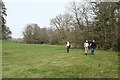
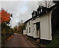
Uplowman: near Uplowman Court
Footpath in valley below Uplowman House
Image: © Martin Bodman
Taken: 10 Apr 2010
0.16 miles
6
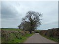
Trees by the ridge road north of Uplowman
This road runs north from Uplowman along the ridge to the east of the valley of the River Lowman
Image: © David Smith
Taken: 23 Mar 2015
0.24 miles