IMAGES TAKEN NEAR TO
Turnpike, TIVERTON, EX16 7BN
Introduction
This page details the photographs taken nearby to Turnpike, EX16 7BN by members of the Geograph project.
The Geograph project started in 2005 with the aim of publishing, organising and preserving representative images for every square kilometre of Great Britain, Ireland and the Isle of Man.

There are currently over 7.5m images from over14,400 individuals and you can help contribute to the project by visiting https://www.geograph.org.uk
Image Map
Images are licensed for reuse under creativecommons.org/licenses/by-sa/2.0
Notes
- Clicking on the map will re-center to the selected point.
- The higher the marker number, the further away the image location is from the centre of the postcode.
Image Listing (96 Images Found)
Images are licensed for reuse under creativecommons.org/licenses/by-sa/2.0
Image
Details
Distance
1
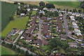
Sampford Peverell : Village Scenery
Looking towards houses in the village of Sampford Peverell.
Image: © Lewis Clarke
Taken: 11 Jul 2015
0.03 miles
2

Sampford Peverell : Daffodils
The daffodils brightening up the entrance into Sampford Peverell.
Image: © Lewis Clarke
Taken: 15 Apr 2021
0.04 miles
3
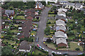
Sampford Peverell : Blackdown View
Looking down towards Blackdown View in the village of Sampford Peverell.
Image: © Lewis Clarke
Taken: 11 Jul 2015
0.07 miles
4

Sampford Peverell : St John the Baptist Churchyard Extension
A sign welcoming people to the church extension.
Image: © Lewis Clarke
Taken: 14 Aug 2018
0.08 miles
5

Sampford Peverell : St John the Baptist Churchyard Extension
The land belongs to the church.
Image: © Lewis Clarke
Taken: 14 Aug 2018
0.09 miles
6
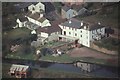
House and canal in Sampford Peverell
Seen from a hot air balloon (scanned from colour slide)
Image: © David Smith
Taken: 17 Mar 1990
0.11 miles
7

Sampford Peverell : Grand Western Canal
Swans and cygnets along the canal.
Image: © Lewis Clarke
Taken: 9 Jul 2022
0.12 miles
8

Sampford Peverell : Manleys B&B
A sign for a B&B with a heron in the garden.
Image: © Lewis Clarke
Taken: 14 Jul 2019
0.12 miles
9

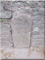
Ordnance Survey Rivet
This OS rivet can be found on the milestone. It marks a point 98.940m above mean sea level. http://www.geograph.org.uk/photo/4874690
Image: © Adrian Dust
Taken: 20 Mar 2016
0.12 miles
10
Mile Stone
There is an Ordnance Survey rivet on the top. http://www.geograph.org.uk/photo/4874696
Image: © Adrian Dust
Taken: 20 Mar 2016
0.12 miles