IMAGES TAKEN NEAR TO
Lime Road, TIVERTON, EX16 6JA
Introduction
This page details the photographs taken nearby to Lime Road, EX16 6JA by members of the Geograph project.
The Geograph project started in 2005 with the aim of publishing, organising and preserving representative images for every square kilometre of Great Britain, Ireland and the Isle of Man.

There are currently over 7.5m images from over14,400 individuals and you can help contribute to the project by visiting https://www.geograph.org.uk
Image Map
Images are licensed for reuse under creativecommons.org/licenses/by-sa/2.0
Notes
- Clicking on the map will re-center to the selected point.
- The higher the marker number, the further away the image location is from the centre of the postcode.
Image Listing (170 Images Found)
Images are licensed for reuse under creativecommons.org/licenses/by-sa/2.0
Image
Details
Distance
1
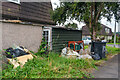
Tiverton : Lime Close
Lime Close in Tiverton.
Image: © Lewis Clarke
Taken: 23 Aug 2021
0.02 miles
2

Tiverton : Lime Close
Looking along Lime Close.
Image: © Lewis Clarke
Taken: 23 Aug 2021
0.02 miles
3
Tiverton : Lime Road
Lime Road at the junction with Lime Close.
Image: © Lewis Clarke
Taken: 23 Aug 2021
0.02 miles
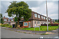
4

Tiverton : Cowleymoor Scenery
Looking down towards the Cowleymoor estate in Tiverton.
Image: © Lewis Clarke
Taken: 11 Jul 2015
0.03 miles
5
Tiverton : Lime Close
Looking along Lime Close in Tiverton.
Image: © Lewis Clarke
Taken: 23 Aug 2021
0.04 miles
6
Tiverton : Holly Close
An empty house on Holly Close.
Image: © Lewis Clarke
Taken: 23 Aug 2021
0.06 miles
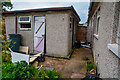
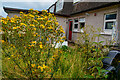
7

Tiverton : Holly Road
A bush at a house on Holly Road.
Image: © Lewis Clarke
Taken: 23 Aug 2021
0.07 miles
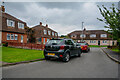
8

Tiverton : Holly Close House
A house on Holly Close.
Image: © Lewis Clarke
Taken: 23 Aug 2021
0.07 miles
9

Tiverton : Holly Close House
A boarded up house on Holly Close.
Image: © Lewis Clarke
Taken: 23 Aug 2021
0.07 miles
10
Tiverton : Holly Close House
A house on Holly Close.
Image: © Lewis Clarke
Taken: 23 Aug 2021
0.07 miles