1
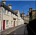
St Andrew's Street, Tiverton
On the immediate left is a former Bible Christian Chapel, shown in
Image Next is the building described at https://historicengland.org.uk/listing/the-list/list-entry/1384882?section=official-list-entry ; " in 1881 (as far as can be judged from the census return) the building was the Star Inn". Ahead are the buildings shown in
Image
Image: © Derek Harper
Taken: 17 Jun 2021
0.00 miles
2
Tiverton : St Andrew's Street
St Andrew's Street in Tiverton as seen from the town hall.
Image: © Lewis Clarke
Taken: 12 Oct 2011
0.01 miles
3
Tiverton : St George's & Scenery
Looking towards the top of the church and St Andrew's Street.
Image: © Lewis Clarke
Taken: 12 Oct 2011
0.01 miles
4
No parking in St Andrew Street, Tiverton
Double yellow lines on both sides of the narrow street indicate no parking at any time.
Image: © Jaggery
Taken: 23 Jul 2019
0.01 miles
5
St George's Church, Tiverton
Grade I listed. "The 3-bay west end rises high above the level of St Andrew's Street on a stepped plinth. The centre bay is a pedimented projection with blind windows matching those on the north and south sides and smaller recesses on either side. Above the pediment there is a stone pilastered bellcote with louvred round-headed openings and a tent lead roof with a weathervane ... " https://historicengland.org.uk/listing/the-list/list-entry/1384825 . "Begun 1714-1716 to the designs of John James ... Completed 1727-1733 after a period of use as a warehouse". Cherry & Pevsner say "Devon's best C18 town church". See also images at https://www.geograph.org.uk/search.php?i=135864080 .
Image: © Derek Harper
Taken: 17 Jun 2021
0.01 miles
6
Tiverton : St George's Church
Looking across St Andrew's Street towards the church.
Image: © Lewis Clarke
Taken: 12 Oct 2011
0.01 miles
7
St Andrews Street, Tiverton
St George's Parish Church is on the left with the Museum of Mid Devon Life further down the street on the left.
Image: © Tom Jolliffe
Taken: 20 Oct 2011
0.01 miles
8
St George's Way, Tiverton
Image: © Alex McGregor
Taken: 6 Aug 2014
0.01 miles
9
Tiverton : Construction Site
A construction site off St Andrew Street in Tiverton.
Image: © Lewis Clarke
Taken: 12 Sep 2019
0.01 miles
10
St George's Parish Church, Tiverton
The view of the church from the main street up through the town.
Image: © Tom Jolliffe
Taken: 20 Oct 2011
0.01 miles


