
IMAGES TAKEN NEAR TO
Elton Close, TIVERTON, EX16 5FR
Introduction
This page details the photographs taken nearby to Elton Close, EX16 5FR by members of the Geograph project.
The Geograph project started in 2005 with the aim of publishing, organising and preserving representative images for every square kilometre of Great Britain, Ireland and the Isle of Man.

There are currently over 7.5m images from over14,400 individuals and you can help contribute to the project by visiting https://www.geograph.org.uk
Image Map
Images are licensed for reuse under creativecommons.org/licenses/by-sa/2.0
Notes
- Clicking on the map will re-center to the selected point.
- The higher the marker number, the further away the image location is from the centre of the postcode.
Image Listing (170 Images Found)
Images are licensed for reuse under creativecommons.org/licenses/by-sa/2.0
Image
Details
Distance
1

Tiverton : Rackenford Meadow
Looking towards construction at the Taylor Wimpey Rackenford Meadow's site.
Image: © Lewis Clarke
Taken: 10 Jun 2016
0.02 miles
2

Tiverton : Rackenford Meadow
Looking out across the development at Rackenford Meadow.
Image: © Lewis Clarke
Taken: 10 Jun 2016
0.04 miles
3

Tiverton : Grassy Field
A helicopter has landed beside the Rackenford Meadows development.
Image: © Lewis Clarke
Taken: 6 Apr 2017
0.04 miles
4
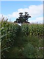
Exe Valley Way crossing a field of maize
The footpath follows a straight path through this field, passing two solitary trees; around the trees the maize is stunted through the dryness of the soil because of the trees.
Image: © David Smith
Taken: 14 Sep 2011
0.05 miles
5
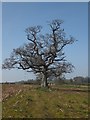
Exe Valley Way crossing a field where maize was grown
This is the same view as in Image, taken six months earlier
Image: © David Smith
Taken: 30 Mar 2012
0.05 miles
6

Tiverton : Rackenford Meadow
Looking to a road heading through the new residential development.
Image: © Lewis Clarke
Taken: 10 Jun 2016
0.07 miles
7

Tiverton : Grassy Field
A grassy field on the outskirts of Tiverton as seen from the Tomswell Allotments.
Image: © Lewis Clarke
Taken: 15 Jul 2013
0.07 miles
8
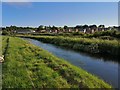
Tiverton : Heathcoat Leat
A leat providing water to the nearby Heathcoat Fabrics.
Image: © Lewis Clarke
Taken: 19 Jun 2019
0.07 miles
9

A triangle of land between the waters
The River Exe runs to the right of shot, with the Mill Leat taking a course further to the left. That forms a large pasture to the west of Tiverton
Image: © Neil Owen
Taken: 24 Apr 2026
0.08 miles
10

Tiverton : Tomswell Allotments
Looking towards the growing greenery in the Tomswell Allotment.
Image: © Lewis Clarke
Taken: 15 Jul 2013
0.08 miles