IMAGES TAKEN NEAR TO
Culm Davy, Hemyock, CULLOMPTON, EX15 3UP
Introduction
This page details the photographs taken nearby to EX15 3UP by members of the Geograph project.
The Geograph project started in 2005 with the aim of publishing, organising and preserving representative images for every square kilometre of Great Britain, Ireland and the Isle of Man.

There are currently over 7.5m images from over14,400 individuals and you can help contribute to the project by visiting https://www.geograph.org.uk
Image Map (Loading...)


Getting Data...Please wait
Leaflet Map data © OpenStreetMap
Images are licensed for reuse under creativecommons.org/licenses/by-sa/2.0
Notes
- Clicking on the map will re-center to the selected point.
- The higher the marker number, the further away the image location is from the centre of the postcode.
Image Listing (11 Images Found)
Images are licensed for reuse under creativecommons.org/licenses/by-sa/2.0
Image
Details
Distance
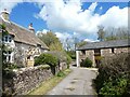
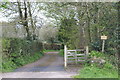
2
A curious wall at Lugg's
The stone wall has a second wall to act as a surface drain for a local stream
Image: © David Smith
Taken: 4 May 2021
0.02 miles
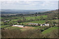
3
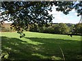
Field above Culm Davy
One of a bocage-like pattern of fields on the Blackdown Hills above the hamlet, seen here from beneath an oak and an ash.
Image: © Derek Harper
Taken: 4 Oct 2010
0.13 miles
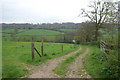
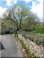
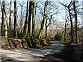
8
Road near Goodall's Farm
The road runs along the west side of the valley
Image: © David Smith
Taken: 4 May 2021
0.14 miles
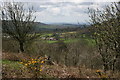
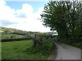
10

Road from Culm Davy to Wellington Hill
Image: © David Smith
Taken: 30 Aug 2010
0.24 miles