IMAGES TAKEN NEAR TO
Hemyock, CULLOMPTON, EX15 3QS
Introduction
This page details the photographs taken nearby to EX15 3QS by members of the Geograph project.
The Geograph project started in 2005 with the aim of publishing, organising and preserving representative images for every square kilometre of Great Britain, Ireland and the Isle of Man.

There are currently over 7.5m images from over14,400 individuals and you can help contribute to the project by visiting https://www.geograph.org.uk
Image Map
Images are licensed for reuse under creativecommons.org/licenses/by-sa/2.0
Notes
- Clicking on the map will re-center to the selected point.
- The higher the marker number, the further away the image location is from the centre of the postcode.
Image Listing (5 Images Found)
Images are licensed for reuse under creativecommons.org/licenses/by-sa/2.0
Image
Details
Distance

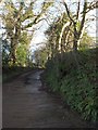
2
Lane to Burrow Hill Farm
A no through road southeast of Hemyock, winding through the gloom above the Culm valley.
Image: © Derek Harper
Taken: 25 Feb 2012
0.12 miles
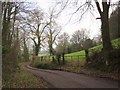
3

Fields above Hemyock
From the lane shown in Image, looking towards Hemyock in the Culm valley. Pounds House is across the pasture fields. The lane can be seen continuing on the right. It's very gloomy.
Image: © Derek Harper
Taken: 25 Feb 2012
0.13 miles
4
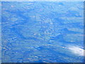
The Culm Valley at Hemyock
Two valleys in fact, the River Culm runs down the left [north side] of the low ridge and the Bolham River to the right. Hemyock, at the confluence, is at lower left.
Image: © M J Richardson
Taken: 30 Dec 2014
0.13 miles