IMAGES TAKEN NEAR TO
Clayhidon, CULLOMPTON, EX15 3QA
Introduction
This page details the photographs taken nearby to EX15 3QA by members of the Geograph project.
The Geograph project started in 2005 with the aim of publishing, organising and preserving representative images for every square kilometre of Great Britain, Ireland and the Isle of Man.

There are currently over 7.5m images from over14,400 individuals and you can help contribute to the project by visiting https://www.geograph.org.uk
Image Map
Images are licensed for reuse under creativecommons.org/licenses/by-sa/2.0
Notes
- Clicking on the map will re-center to the selected point.
- The higher the marker number, the further away the image location is from the centre of the postcode.
Image Listing (11 Images Found)
Images are licensed for reuse under creativecommons.org/licenses/by-sa/2.0
Image
Details
Distance
2
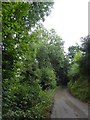
Road through the woods near The Knowle
The minor road runs through the woodland at the top of the valley named as Hole; the farm is at the head of this valley
Image: © David Smith
Taken: 3 Sep 2016
0.02 miles
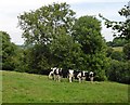
8
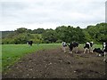
Cattle and the woods at Hole
Looking towards the woods in the valley north of the road to The Knowle
Image: © David Smith
Taken: 3 Sep 2016
0.11 miles
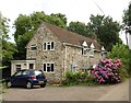
9
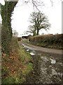
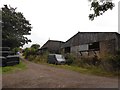
Lane at Knowle Farm
Taken at a double bend of the lane from Smeatharpe to Burrow's Farm, with a farm building at Knowle Farm.
Image: © Derek Harper
Taken: 25 Feb 2012
0.16 miles