IMAGES TAKEN NEAR TO
Ashill, CULLOMPTON, EX15 3NH
Introduction
This page details the photographs taken nearby to EX15 3NH by members of the Geograph project.
The Geograph project started in 2005 with the aim of publishing, organising and preserving representative images for every square kilometre of Great Britain, Ireland and the Isle of Man.

There are currently over 7.5m images from over14,400 individuals and you can help contribute to the project by visiting https://www.geograph.org.uk
Image Map
Images are licensed for reuse under creativecommons.org/licenses/by-sa/2.0
Notes
- Clicking on the map will re-center to the selected point.
- The higher the marker number, the further away the image location is from the centre of the postcode.
Image Listing (32 Images Found)
Images are licensed for reuse under creativecommons.org/licenses/by-sa/2.0
Image
Details
Distance
1

Ashill : Grassy Field & Old School House
Old School House beyond the field outside of Ashill in Mid Devon.
Image: © Lewis Clarke
Taken: 6 Apr 2013
0.02 miles
2
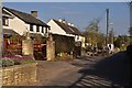
Ashill : Hackpen View
A road heading out of Ashill and into the countryside.
Image: © Lewis Clarke
Taken: 6 Apr 2013
0.03 miles
3
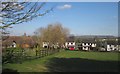
East end of Ashill
Seen from the green lane from Allhallows Farm as it reaches the first houses in the village. The roof of St Stephen's church, built in 1882 as a combined chapel of ease and schoolroom, is on the left.
Image: © Derek Harper
Taken: 3 Feb 2012
0.03 miles
4

The old school at Ashill
Showing separate toilets for boys and girls and demolished dividing wall.
Image: © Nick Chipchase
Taken: 2 Sep 2016
0.04 miles
5

St Stephen's church, Ashill
Built in 1882 as a combined chapel of ease and schoolroom, the latter divided off by shutters. "A carefully organised design successfully integrating secular and ecclesiastical components, with imaginative use of materials and attention to detailing, all done on a limited budget" http://www.britishlistedbuildings.co.uk/en-95798-ashill-church-uffculme .
Image: © Derek Harper
Taken: 3 Feb 2012
0.04 miles
6
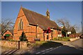
Ashill : Ashill Church
Built in 1882 to designs by R M Fulford. Red brick in Flemish bond with Ham Hill stone dressings; tiled roof, the chancel with crested ridge tiles. Plan: nave, south porch, chancel; bellcote at east apex of nave gable wall above chancel arch; hall to north, set transeptally, is divided from the church by a removable internal glazed partition.
Image: © Lewis Clarke
Taken: 6 Apr 2013
0.04 miles
7

Old Boundary Marker
Church Boundary Marker against the boundary wall of Ashill Court Farm, Ashill, opposite St Stephen's church, and facing southeast. Uffculme parish. Inscribed S. Assumed to denote the boundary of the land owned by St Stephen's church.
Milestone Society National ID: DV_UFFC01em
Image: © N Savage
Taken: 12 Jul 2020
0.05 miles
8

Ashill : Batts Park
Batts Park heading through the village of Ashill in Mid Devon.
Image: © Lewis Clarke
Taken: 6 Apr 2013
0.06 miles
9
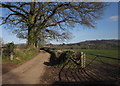
Lane to Hackpen Mill
A scene at the northern edge of Ashill, with the quiet lane passing beneath trees and past a gate. Hackpen Hill is on the right.
Image: © Derek Harper
Taken: 3 Feb 2012
0.06 miles
10
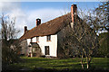
Uffculme: cottage at Ashill
Looking north west
Image: © Martin Bodman
Taken: 1 Mar 2006
0.06 miles