IMAGES TAKEN NEAR TO
Little Normans, CULLOMPTON, EX15 2LP
Introduction
This page details the photographs taken nearby to Little Normans, EX15 2LP by members of the Geograph project.
The Geograph project started in 2005 with the aim of publishing, organising and preserving representative images for every square kilometre of Great Britain, Ireland and the Isle of Man.

There are currently over 7.5m images from over14,400 individuals and you can help contribute to the project by visiting https://www.geograph.org.uk
Image Map
Images are licensed for reuse under creativecommons.org/licenses/by-sa/2.0
Notes
- Clicking on the map will re-center to the selected point.
- The higher the marker number, the further away the image location is from the centre of the postcode.
Image Listing (6 Images Found)
Images are licensed for reuse under creativecommons.org/licenses/by-sa/2.0
Image
Details
Distance
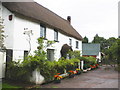
1
United Reformed Church, Norman's Green
Image: © Roger Cornfoot
Taken: 22 Jul 2010
0.05 miles
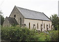
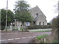
2
Norman's Green : Plymtree Reformed Church
The church and road in Norman's Green.
Image: © Lewis Clarke
Taken: 14 Aug 2014
0.06 miles
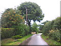
3
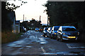
Norman's Green : Old Bridge Road
Old Bridge Road heading out of Norman's Green in East Devon.
Image: © Lewis Clarke
Taken: 14 Aug 2014
0.06 miles
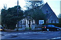
4
Plymtree United Reformed Church, Normans Cross
Image: © Martin Southwood
Taken: 13 Jan 2006
0.10 miles